
News
Blogpost Cleanup
I've gone through all of the old blogposts and removed everything that is of no more relevance today, like posts about shipping problems during the pandemic, to make those who are more visible again.
The Tichitt Culture
Currently, there is time to update my maps and especially to continue work on the The Ancient World map in DIN A1 announced last year. My current focus is on the African section of this map. Recently, I added the Tichitt culture both to the new one and my The Bronze Age World map. Another early African civilization whose homeland was largely swallowed by the expanding desert.
New Digital Edition: Ancient Persia DIN A1
The penultimate of the recently announced series of smaller maps sized DIN A1 (841 x 594 mm) is now available as digital edition. The Achaemenid Empire (DIN A1) is an excerpt of the larger map Dawn of the Classical World focusing just on the ancient Persian Empire occupying the eastern half of the bigger map.
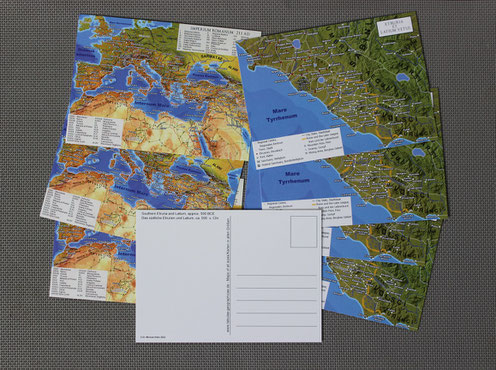
Digital Edition: Imperium Romanum 211AD (A1)
The next of the DIN A1 (841 x 594 mm) sized maps is now available as digital edition. The smaller version of Imperium Romanum 211 AD is based on the older The World of Ancient Rome prints, it was on one side this double sided poster, however the newly released map was updated with all new settlements and further improvements made to the main map since the end of 2017.
New Variant: Classical Greece (DIN A1)
The first of the recently announced series of smaller maps sized DIN A1 (841 x 594 mm) is now available as digital edition. Classical Greece (DIN A1) is an excerpt of the larger map twice its size, focusing just on the core areas. While some areas had to be left out, the new version arguably uses the available canvas much more efficiently, with much less space devoted to the open sea. Thus despite being half the size, it still includes most of the content.
Some Smaller Maps
Currently, a series of smaller maps, sized DIN A1 (841 x 594 mm), is being prepared. They will require only half the space on a wall than their huge brethren in DIN A0 (1189 x 841 mm). The new maps are mostly either downsized or excerpts of existing ones, but at least one of them will cover new grounds. They are all briefly introduced here:
Development Update: Postcard Ancient Egypt
To quicker increase our product portfolio, Sardis Verlag released a number of DIN A6 sized postcards (14,8 x 10,5 cm), either with unique content or as scaled down versions of the big wall maps. Usually the latter were accompanied by a corresponding postcard a few weeks later. Although I really liked these miniaturized maps, the practice stopped with my map of Ancient Egypt and the termination of Sardis Verlag in 2017, in favor of more large scale maps like Classical Greece. Now, with my other Ancient world map projects released over the course of the last year, the time has come to finish the once planned Ancient Egypt postcard too.
Individually created Maps
On customer request it is possible to create all kind of new maps, not limited to the ancient world, totally from scratch according to your wishes. They can be destined for your own publication, exhibitions, or purely private purposes. Every topic, size and shape, between a small black and white survey map for a book project and a full sized wall map, can be realized. The price depends on the required amount of work and if additional geodata is required.
New Edition: Dawn of the Classical World (2022)
A new edition of my wall map Dawn of the Classical World is now available. Updated using new research, that was published since its initial release in 2015, the map is featuring more than 300 additional toponyms, including over 200 new settlements to bring the total number to over 1000.
New Maps: "The Bronze Age World" and "The Parthian Empire and the Silk Road"
Two new maps are finally ready for public release, The Bronze Age World and The Parthian Empire and the Silkroad. Both are now available as download version and present on their respective preview pages. While custom made prints such as on canvas are also possible, a regular paper edition is currently only scheduled for late summer or fall.
New Prints: Imperium Romanum 211 AD (2021)
Since I was slowly running out of the rolled up 2017 prints of Imperium Romanum 211 AD the time has come for a new edition. The differences are not as dramatic as between the old Sardis Verlag map from 2014 and the second generation map, but nevertheless noticeable. Four years worth of small improvements and additions have increased the level of detail in some areas considerably. Such changes are always included in each custom made prints or download version, all exported from the most recent files. But I have also included few larger changes reserved for a new edition.
Making Maps with QGIS
One of my first blog posts for the old Sardis Verlag homepage was a “Making of” for the Imperium Romanum map. It even existed as a promotional poster back then. Since I am asked this question from time to time, I thought it might be good to write something like this again.
All my maps are nearly entirely done with QGIS, an open source Geo Information System. However, for data collection I mostly use Google Earth Pro.
The Antonine Itinerary
I've added a new page with a map visualizing the Antonine Itinerary, an imperial Roman directory of 17 routes with over 2000 waystations, covering a greater part of the Roman road network.
Development Update 3.21: The Bronze Age World
During the last two months work on the Bronze Age map could again progress well. I mainly focused on improving the countries of the Hittite Empire, the major power dominating the upper central part of the new map. I am not yet finished with the Hittite lands, but at least more than the basic framework is now on the map.
2021 Development Update
The holidays are over and the new year has come, thus it is a good time to give a small update showcasing the new maps I am currently working on. At the moment, I have three different projects from very different eras in development.
Development Update: The Bronze Age World
Today is the 5th anniversary of the start of my late Bronze Age map project. In November 2015 I finished the initial version of the Dawn of the Classical Word/Persian Empire map for Sardis Verlag and thereafter laid down the foundations for new projects. Back than I had planned two new maps: The Parthian Empire and the World of the Bronze Age. The former was released by Sardis Verlag in spring 2016, the latter so far only as its offspring New Kingdom Egypt, in fall 2016.
Bronze Age Map: Central Asia
Needless to say that in this trying times my upcoming The Bronze Age World wall map was not
progressing at the desired pace. Nevertheless, since the last update I could add a greater number of features; cities, mountains and rivers, to the Hittite Empire, Elam and most importantly
Central Asia.
Unlike on my previous maps, the Bronze Age World ancillary map will cover a much larger area than the main map to include many important cultures and territories that found themselves
outside of the highly detailed area, but should not be left out. One of them is Central Asia, the source of invaluable tin and gemstones like Lapislazuli for the middle eastern civilizations and
itself the site of many fascinating early cultures and cities.
Development Update: The Bronze Age World
The time has come for a small update showing the current state of my upcoming Bronze Age map. While the map will still only depict the polities of the 13th century BCE, I’ve continued to expend the scope by including a greater number of earlier sites, as well as former natural features such as shifted or dried out river courses.
Yam - The Lost Country
The localization of Yam, a country mentioned in ancient Egyptian sources, is one of the unsolved problems of Egyptology and for reconstructing the historical geography of eastern Africa. So far the majority of scholars preferred a location in the Nile valley, partially because of a lack of good alternatives. Since the turn of the century, in increasing amount of new archaeological data supports theories that search for Yam in the Western Desert of Nubia. The continued exploration of this extremely dry and inaccessible region in the borderlands of Egypt, Sudan, Libya and Chad has produced evidence for larger numbers of former oases and well watered spots that could support sedentary and pastoral communities well into the Bronze Age.
Status Update - The Study of Antiquity and the Middle Ages
In the last few months the final steps to finish my PhD kept my occupied and I couldn‘t devote as much time to research my upcoming Bronze Age map as I had wished or hoped for. Thus no progress update yet, but due to the current situation I have an ample amount of time now. At the moment I am working on Elam and all areas of greater Iran. I hope to have some preview images ready for next months.
So far all parcels are still being delivered at a normal pace, while Canvas prints and other custom made maps are produced as usual. However, due to the great dynamic of this extraordinary situation, COVID-19 epidemic induced delays can't be fully excluded.
Bronze Age Map: The Rivers of Babylon
During the last moths I could resume work on the Bronze Age map which has progressed well. Despite the considerable work already done for the Ancient Egypt map, this will be a long project. Hopefully, it can be finished during the course of winter, but more likely it will be summer again before the new map is ready for printing. The focus is currently on the two major powers of Mesopotamia, the Middle Assyrian kingdom and Kassite Babylonia, as well as the landscape they inhabited. The next steps will be Elam and the Hittite Empire. Once the major framework is complete, thus all great powers of the era are on the map and the Bronze Age landscape is reconstructed, I will focus on minor actors in the surrounding territories and especially the long distance trade networks. An additional smaller scale ancillary map will give a wider picture, including far away places like Cornwall and Afghanistan from where essential tin and exotic goods like Lapis Lazuli were transported to the Middle east.
Classical Greece: Completed and Available!
My newest huge wall map, Classical Greece and its Neighbors, is finally completed and DIN A0 sized HD prints are now available for purchase. As usually detailed commentaries and the complete bibliography can be found on the corresponding product page.
Sardis and Sardis Verlag
The Classical Greece map is now essentially complete. I will use the next few weeks for polishing it a bit more, before having a release candidate for prints ready by the end of the month. Meanwhile I’ve already begun to assemble the required literature to finish the Bronze Age map, making good progress here too.
Future Plans: Back to the Bronze Age
During the last weeks the Classical Greece map progressed well and I could finish Cyprus and Troas while making progress in Thrace. Recently, a new book arrived, The Archaeology of Lydia. In the long term it should be a very valuable addition to my private library, while helping me to finish the Classical Greece map in the coming weeks. With the completion of this map in sight, it’s time again to think about future projects.
Development Update: Classical Greece
During the last 6 weeks I could again devote much time to continue my work on the Classical Greece map. I added many settlements and details over the entire Aegean region and filled some gaps in Italy. The DIN A0 version of the map now has about 900 settlements of all kind, the same as on the first edition of my Roman Empire map.
Update: Roman Era Hesse
Last week I added about 100 new Roman sites to the Roman Era Hesse map, completing the civil settlements in the northern Wetterau. By now more work for this map is done than left to do.
Classical Greece: A first Print
The Classical Greece is map is progressing much slower than I originally anticipated. Due to more urgent needs I can’t devote as much of my time to the project than I hoped for. Nevertheless here is a first, DIN A1 sized, print covering the central parts of the larger map.
Development Update: Roman Era Hesse
Recently, I‘ve updated the Roman Era Hesse page with a new version of my map and added the bibliography. However, the map is still very work in progress and far from polished. The Roman roads and settlements in the Main Taunus Kreis are now completed and a number of features were also added elsewhere. I've also made a few general improvements, like the better placement of labels. The civil settlements in the Wetterau and Hessian Ried regions will be next. Once everything is on the map I can begin to place the larger labels with the names of the Civitates or geographical features.
Development Update: Classical Greece
The Classical Greece map is currently progressing well and has begun to look quite nicely. Thus I thought this might be a good time for a development update:
Classical Greece
Currently I am making great progress in finishing another old project, a highly detailed map of Classical Greece.
Book: An Urban Geography of the Roman World, 100 BC to AD 300
In autumn, during one of my visits in the library, I've found a relatively new and for me very interesting book: J. W. Hanson's An Urban Geography of the Roman World, 100 BC to AD 300, which was published in 2016. If it had been available a few years earlier it would have saved me hundreds of hours of work when I begun compiling the Roman Empire map in late 2013 and during our Antonine Plague project before.
New prints: The World of Ancient Rome, double sided poster
The old Sadisverlag folded Imperium Romanum posters are almost sold out, so the time had come to think about a better replacement. Instead of just reprinting the old posters I decided to make something else. The result is the new double sided poster, The World of Ancient Rome.
Roman Era Hesse
I‘ve added another one of my projects to this site. One of my long term projects is to compile an highly detailed historical atlas of my home region, the Odenwald. The first step is a map of the Odenwald and surrounding territories during the Roman Era. This particular map should originally just show the immediate surroundings of the Roman Villa Rustica Haselburg The project has since grown in scope, currently I plan to eventually cover all parts of the province Germania Superior situated to the east of the Rhine, which will give the reader a more complete picture.
The current work in progress map can be viewed on its own sub site: Das römische Hessen
It will be continuously updated until completion.
Full Bronze Age Map
My current project: Expanding the Ancient Egypt map to cover all cultures of the late Bronze Age eastern Mediterranen and Middle East.
Roman Era Population Numbers
Another one of my old Sardis Verlag blog posts. Here I want to try to give the reader some population numbers for the territories depicted on the Imperium Romanum 211 AD map.
Prints in DIN A2
On demand my maps can be printed in other formats than the standards they were designed for. In this post I will show two examples in DIN A2 (59,4 x 42 cm), the largest size that can be shipped rolled up globally for 3,70 €.
New rolled up Imperium Romanum 211 AD maps
The rolled up Imperium Romanum map was Sardis Verlags most popular product and virtually sold out since the first weeks of 2017. Now a reprinted and heavily improved second edition has entered production. Over the last three years I made a number of changes affecting both the general and appearance and content. Thus compared to the first edition from 2014 there are quite a few improvements that I will introduce below.
New inscriptions from Saudi Arabia and the extent of Roman rule along the Red Sea
An old blogpost from me. Originally posted in December 2014 on www.sardisverlag.de. Since I don't want it to get lost once the old page will shut down and since it is still relevant for my Imperium Romanum map, I decided to repost it here.
Shop Activated
Since by now Sardis Verlag has stopped selling its products directly, I have activated the shop in this page. You are able to purchase HD paper prints of the maps from the former Sardis Verlag catalogue and newly made deluxe canvas prints. For now you can only pay with the popular online payment system PayPal. However PayPal also allows the use of Debit or Credit cards, without the need of your own PayPal account. Further options are planned in the near future.
A new home for my maps of the Ancient World
Welcome to tabulae-geographicae.de,
this website is intended to offer a new and permanent home for my maps of the Ancient World. A replacement for www.sardisverlag.de that will be shut down in the near future. However, currently HD prints of all my maps are still available via www.sardisverlag.de. In the coming months my related non commercial projects will also be presented here.
As soon as Sardis Verlag stops to sell their products directly, you will be able to purchase them in a small integrated web shop on this site.
In March the maps will again be sold on Amazon.de and other European marketplaces. Probably in summer a new edition of the Roman Empire map should be again become available on Amazon.com.