
Dawn of the Classical World: A Map and its Era
The creation of this map was mainly motivated by my fascination for the era at the very beginning of classical antiquity, the moment it transitioned from archaic to classical period. Unlike the Roman Empire map I did not choose a fixed date, but tried to depict the ancient world in the decades before and after 500 BCE.
The 6th century BCE was a fascinating, incredibly colorful period of progress and change. During this time the outlines of the classical ancient world were formed. A world that would continue to exist for 1000 years and decisively influenced our presence. For example through the concept of citizenship, that evolved when the increasingly complex societies of the ever larger city states made the introduction of detailed and obligatory laws a necessity.
The previous centuries had been dominated by the great colonization movements of the Greeks and Phoenicians. Exploring the unknown in search of fertile land and new trading opportunities, they established a dense network of colonies and trading posts around the Mediterranean basin and neighboring coasts.
In the 6th century the countless city states and cultures of that region had established close ties with each other through long distance trade. Today, the products of Greece and Etruria can be found in the remnants of settlements and burial mounds in the lands of the Scyths beyond the northern shores of the Black Sea, in Egypt and the African interior, as well as the territory of the Hallstatt era Celts north of Alps.

Examples of contemporary art: Kouros from Samos (Photo: Adam Carr), The Prince of
Glauberg (Photo: Heinrich Stürzl), Apollo of Veii (Photo: Giorces), all Wikimedia Commons.
In what is today southern Germany the Heuneburg, with its Mediterranean style mudbrick wall, evolved into one of the first city like centers of central Europe. At the Atlantic Ocean the western Phoenicians ventured to the north and south along the African and Portuguese coasts. Shortly thereafter they would be unified under the leadership of Carthage.
In the east the Persians created the first true multicultural Empire, incorporating vastly different cultures from Bactria to Egypt. During the reign of Dareios I. and his successor Xerxes the Empire achieved its greatest extend, while its confrontation with the cities of Hellas left deep marks in history.
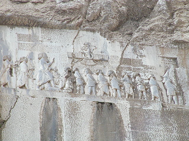
Behistun-Inscription commemorating the events and victories during Dareios
ascension (Photo: Hara1603, Wikimedia Commons)
The west had its share in conflicts too, when the rivalry between the ascending Etruscan league, Carthage, new hegemon of the western Phoenicians with its own ambitions, and the Greek colonies peaked in the battles of Himera and Kyme.
Just as it happened at many place during these times, the kings were overthrown in Rome, which enjoyed a first period of great prosperity, an the Republic founded, which once would surpass all others.

Model of archaic Rome during the late Tarquin dynasty, Museo della Civiltà Romana. (Photo: Author)
This was also an era rich in great thinkers and personalities: Founding fathers of western philosophy and science like
Pythagoras of Samos, Heraklit of Ephesus, Thales or the geographer Hekataios of Milet lived side by side with tyrants such as Phalaris of Akragas or Polykrates of Samos.

Tunnel of Eupalinos. 6th century BCE, Samos. (Photo: Author)
A world that was transmitted to us especially by the timeless works of Herodotus of Halicarnassus, the father of history.
When making this map my goal was to bring this long gone world back to live, create a map that is much more atmospheric than the first edition of my Roman Empire map. I wanted to cover every bit of geographic information found in Herodotus books, supplemented by other ancient sources and the latest modern research. So far I am not entirely happy with the result and plan to revisit this map sometime in future.
My passion for Roman history resulted in the detailed Etruria and Latium Vetus ancillary map, which was republished as a separate post card sometime later. BY now it is also available on the backside of the World of Ancient Rome double sided posters. The ancillary map is solely devoted to Rome's sphere of influence in the final years of the 6th century BCE. For the first time Rome did take control of old Latium (Latium Vetus) in its entirety, as well as the southern coastal strip down to Terracina. This first "Roman Empire" was only short lived. In the first decades of the 5th century the south, including Antium and Velitrae were occupied by the Volscii, while the Latins in the east were pressed hard by the Aequi. For much of the century Rome had to defend itself in the Alban Hills, while going through a phase of stagnation, economical decline and civil unrest. Only after the conquest of her Etruscan neighbor Veii in 392 (Livius, Dionysius) did Rome begun to rise again.