Maps of the Ancient World
Tabulae-Geographicae - Maps of the Ancient World, a website dedicated to showcase the growing number of my historic maps. Many of them were originally created for and distributed by Sardis Verlag, a now defunct small German publisher.
Attached to this site is a small shop, where you can buy HD prints or download versions of my maps.
News:
Blogpost Cleanup
I've gone through all of the old blogposts and removed everything that is of no more relevance today, like posts about shipping problems during the pandemic, to make those who are more visible again.
The Tichitt Culture
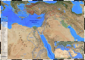
Currently, there is time to update my maps and especially to continue work on the The Ancient World map in DIN A1 announced last year. My current focus is on the African section of this map. Recently, I added the Tichitt culture both to the new one and my The Bronze Age World map. Another early African civilization whose homeland was largely swallowed by the expanding desert.
New Digital Edition: Ancient Persia DIN A1
The penultimate of the recently announced series of smaller maps sized DIN A1 (841 x 594 mm) is now available as digital edition. The Achaemenid Empire (DIN A1) is an excerpt of the larger map Dawn of the Classical World focusing just on the ancient Persian Empire occupying the eastern half of the bigger map.