
The penultimate of the recently announced series of smaller maps sized DIN A1 (841 x 594 mm) is now available as digital edition. The Achaemenid Empire (DIN A1) is an excerpt of the larger map Dawn of the Classical World focusing just on the ancient Persian Empire occupying the eastern half of the bigger map.
While the scale had to be reduced from 1:5 Million to 1:6.5 Million the level of detail in the covered areas is almost identical, due to an equally reduced size of the labels. Smaller maps are typically viewed from a closer distance, thus the changed requirements.
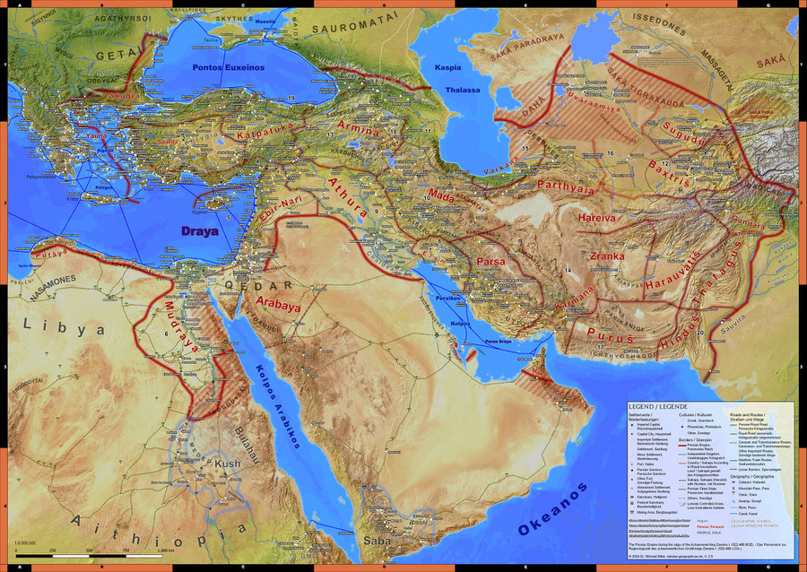
The other major change compared to Dawn of the Classical World is the different map projection used. Dawn of the Classical world was a passion project. Other than the Achaemenid Empire, in a similar scale as Imperium Romanum 211 AD, it should cover as many parts of the wider Mediterranean and Middle Eastern world in this peculiar era as possible. For this I used the Albers projection in an unusual way to bend the eastern parts of the Persian Empire upwards with the sole reason to fit more countries to an DIN A0 sized canvas.
With this requirement removed and the focus solely on the Persian Empire, I could use a more conventional projection with the advantage that the empire, stretching mainly from west to east, fits better onto the smaller canvas. However, with the changed projection about 1000 labels had to be rearranged manually, thus the delay in the release schedule compared to the DIN A1 versions of Ancient Greece and Imperium Romanum 211 AD released last month, which were also based on existing DIN A0 sized wall maps.
Next in line is my Ancient World/Old World map, which I hope to release some time in early summer, covering wider parts of Eurasia and Africa beyond the reach of the great Empires of those times.
Write a comment