
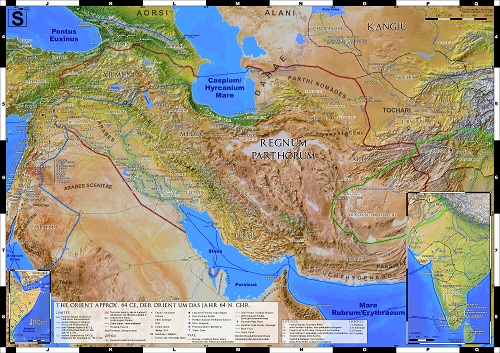
The Parthian Empire Map
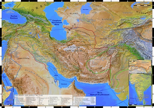
This somewhat smaller DIN A1 sized map was meant as a supplement to my big map of the Roman Empire. It was published by Sardisverlag as The Roman Era Orient. The map depicts Roman Syria and the surrounding client states, the entire Parthian Empire, as well as the remaining states of western Asia together with the major trade routes over land and through the Indian ocean about 64 CE. An expanded and updated version of the original map, The Parthian Empire and the Silk Road, which was enlarged to DIN B1, is available as digital edition or custom made print. The extra space added to the north and east allowed to depict the entire Kushan Empire as well as the course of the ancient silk road through the Tarim basin to Chang'an, capital of the Chinese Han dynasty.
Prints of the Parthian Empire map are also available as part of the double sided World of Ancient Rome poster, for which it was scaled down to 1:6. Million.
Features:
- All nations and provinces with accurate borders and their respective capitals,
- More than 400 named places,
- Settlements and Sanctuaries,
- Important fortresses,
- The Legions of Syria,
- The non-urban peoples of the region,
- Caravan and trade routes,
- Important sea routes,
- Major mining areas,
-
Modified geodata to reflect the ancient topography,
- Format: DIN A1 (59,4 x 84,1 cm) ,
- Scale 1:4.500.000 or 1:6.000.000 (World of Ancient Rome),
- Legend in English and German.
HD prints of this map can be purchased from my online store. Both variants are also available as download.

Commentary
In order to maintain consistency with the Imperium Romanum map, as many parameters as possible were kept unchanged. This includes the scale of 1:4.5 millions, as well as the numbering of the grid and the chosen symbols. Only the standard parallel of the equirectangular projection was changed to 30°N in order to obtain the map segment shown.
Just as for the Imperium Romanum map, the background was composed from landclass and bathymetry data, combined with a shaded relief. The underlying geodata again comes mostly from Natural Earth and the shaded relief was calculated from the SRTM30 data set of the U.S. Geological Survey. The geodata was corrected in those places where the topography has changed significantly since ancient times, especially the coastal areas. In addition, numerous rivers were added.
Borders: During the early principate, both the Roman east and the Parthian Empire largely consisted of the territories of client states, governed by their own kings and dynasts with various degrees of autonomy. However, since these states were considered integral parts of the respective empires [1], it was decided to emphasize the boundary of the imperial realms of influence, instead of the boundary of the actual provinces (as had been the case with the Imperium Romanum map).
In the east, only very little evidence exists for the exact boundaries of the Indo-Parthian Empire. A large part of its history can only be reconstructed from coin finds and their distribution. Even the relationship between the Indo-Parthian Kings and the Great King remains a mystery.
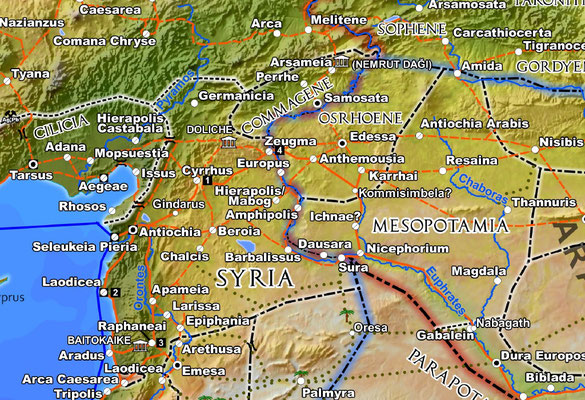
It should also be noted that the political structures on the Roman Levant also had to be simplified on this map. For instance, there are some smaller Tetrarchies that cannot be localized. Among them are the territory of Varus, later assigned to Agrippa II., which had only been written about by Josephus (BJ 2.12.8.), as well as Chalcis, Ampeloessa and Gabe (Plinius NH 5.74), which are suspected to have been located in the relatively unknown rural areas of Lebanon and Anti-Lebanon. They lacked large and easily traceable urban centers and lived centered around numerous local sanctuaries.
In the Roman world, the difference between villages and cities is often only of a legal nature. The Near East of the time was characterized by a network of villages, among which some had the role of regional centers and could rival both the size and the appearance of cities.
The Parthian Empire: Compared to its Roman neighbor, the Parthian Empire has seen relatively little research into its history and topography. So far, there is not even agreement on whether the 18 Kingdoms that made up the Parthian Empire (as recounted by Pliny, NH 6.112) were client states, such as Persis and Charakene, or the 18 direct subordinate regions of the Great King (as recounted by Isodorus in his Mansiones Parthicae), or a combination of both.
Similar caveats apply to the capitals of the empire. Sources note a whole string of cities along the Ktesiphon – Nisa axis as at least temporary seats of the Great King or sites of a royal palace. Examples are Hekatompylos, Rhagai and Ekbatana. The most likely sole candidate for the time frame of interest in this map is Ktesiphon, which is why it was marked as the capital here [2].
The Great Wall of Gorgan, whose construction is often attributed to the Parthians in older literature, according to more recent research [3] dates to the Sassanid era and is therefore not included in the map.
Even the earliest descriptions by Greco-Roman authors of what today is Iran include a people named Paraetaceni (or spelling variations thereof) at different locations and in place name references. This name is a generic term that describes mountain peoples living far from the large population centers and is most likely derived from the old Persian word Paruta, meaning mountain.
Road Network: The existence of a courier system along the King‘s Roads (similar to the Hellenistic and Achaemenid predecessors) is proven by mentions of royal stations in the Mansiones Parthicae of Isodorus Characenus or by the Parthian documents found in Avroman. Given the scarcity of sources, only the route described by Isodoros is noted on the map. It constitutes the backbone of the Parthian Empire, connecting the eastern and western border via all capitals. Most other roads beyond the Roman territories are based on those inscribed in the Tabula Peutingeriana, which shows a state during Parthian times in its eastern part.
Territories under Roman control in the far east of that time also did not yet have many truly Roman roads. In the south, reliable proof only exists for a connection between the provincial capital Antiochia and the Claudian colony Ptolemais, which was established for military reasons in 56. In the Pontus area, an inscription north of Amastris shows that the coastal road was already under construction in 45. It is included in the map, up until Sinope at the boundary of the provincial territories.
Large scale extension of the road network in the east started only with the Flavians. This continued under the adoptive emperors and throughout the Parthian wars of the 2nd century and is documented by various mile stones from Iudaea and Palmyra up to Cappadocia and Pontus.
It follows that the classification of roads is relatively problematic. Typically, a Roman Via Publica is differentiated legally and documented on site through road lists and mile stones, so that it can be clearly recognized even if the road itself does not consist of a man-made road surface. However, the transitions between non-public roads and paths remain fluid, especially in the areas that are adjacent to deserts. In addition, it was always the intention to maintain the road classifications that were used in the Imperium Romanum map. In the end, the decision was made to classify paths through densely populated, geopolitically organized areas as roads, and to include the various side branches of the Silk Road in the east.
Traveling Times in the Red Sea and Beyond: All times noted on the map are the actual travel times for the corresponding route. Given the wind system of the Red Sea and the Indian Ocean, the travel times along a multi-station route may deviate drastically, which can be misleading [4].
Ships had to leave Egypt in summer so that they could cross the Red Sea using the predominant northerly winds of this season. In the Gulf of Aden, they would then encounter the Southwest Monsoon, which allowed to continue towards India, but made a change of course on the Horn of Africa (Aromata Promontorium), so as to travel in a south-western direction along the East African coast, impossible. Doing so only became possible from around November, when the Northeast Monsoon begins. Likewise, the ships had to wait for 8 months in Raphta for the return of the Southwest Monsoon. Back in Egypt, another 6 months had to pass before the next journey could be started in the following July. With the then common rigging (just as with more modern rigging), travel against strong Monsoon winds was practically impossible.
Footnotes:
[1] For example, discussion in M. A. Speidel, Early Roman Rule in Commagene, Scripta Classica Israelica 24 (2005), 1-19.
[2 This is also discussed in B. Jacobs, II.4.2.2 Hauptstädte und Zentren, in U. Hackl, B. Jacobs, D. Weber (Hg.), Quellen zur Geschichte des Partherreiches Textsammlung mit Übersetzungen und Kommentaren Band 1, Vandenhoeck & Ruprecht (2010).
[3] See H. Omrani Rekavandi, E. Sauer, T. Wilkinson, J. Nokandeh, The enigma of the red snake: revealing one of the world’s greatest frontier walls, Current World Archaeology, No. 27 (2008), 12-22.
[4] See L. Casson, Rome's Trade with the East: The Sea Voyage to Africa and India, Transactions of the American Philological Association 110 (1980) 21-36.
Bibliography
Primary Sources
- Ammianus Marcellinus (b. approx. 330, d. after 391 n. Chr.): Res Gestae
- Arrian (b. 85–90, d. after 145/146 CE): Periplus Ponti Euxini
- Cassius Dio (b. approx. 163 - d. after 229 CE): Historia Romana
- Isidorus Characenus (after 26 BCE.): Mansiones Parthicae
- Unknown Author, approx. mid 1. century CE: Periplus Maris Erythraei
- Pliny the Elder (b. 24 - d. 79 CE.): Historia Naturalis
- Strabo (b. 63 BCE. - d. after 23 CE): Geographica
General
- BECHERT 1999: T. Bechert (ed.), Die Provinzen des Römischen Reiches: Einführung und Überblick, Phillip von Zabern (1999)
- BOWMAN 2000: A. K. Bowman, P. Garnsey, University of Cambridge, D. Rathbone (eds.), The Cambridge Ancient History Volume 11. The High Empire, AD 70–192, Cambridge University Press (2000).
- ENCIR: E. Yarshater (ed.) et Al., Encyclopaedia Iranica, www.iranicaonline.org.
- FELDBACHER 2022: R. Feldbacher, Netzwerk Seidenstraße, wbg Philipp von Zabern (2022).
- KLEE 2010: M. Klee, Lebensadern des Imperiums – Strassen im Römischen Weltreich, Theiss (2010).
- LEPELLEY 2001: C. Lepelley, Rom und das Reich in der Hohen Kaiserzeit 44 v. Chr. - 260 n. Chr., Band 2 Die Regionen des Reiches, K.G. Sauer (2001).
- LÖHBERG 2006: B. Löhberg, Das Itinerarium provinciarum Antonini Augusti, Frank & Timme, Berlin (2006).
- MILLER 1916: K. Miller, Itineraria Romana römische Reisewege an der Hand der Tabula Peutingeriana, Unveränd. Nachdr. [d. Ausg.] 1916, Bregenz: G. Husslein, (1988).
- PLEIADES: B. Turner, T. Elliott et. Al., Pleiades - A community-built gazetteer and graph of ancient places, pleiades.stoa.org
- STILLWELL 1976: R. Stillwell, W. L. MacDonald, L. William, M. H. McAlister, The Princeton encyclopedia of classical sites, N.J. Princeton University Press (1976).
- TALBERT 2000: R.J.A. Talbert (ed.), Barrington Atlas of the Greek and Roman World, Princeton University Press (2000).
- TAVO, Tübinger Atlas des Vorderen Orients, Dr. Ludwig Reichert Verlag (1975-1993).
- WBG 2024: M. Blömer, A. Lichtenberger (eds.), Erhaben und den Göttern nahe - "Heilige Berge" der Antike, wbg Philipp von Zabern, Verlag Herder (2024).
- WITTKE 2007: Anne-Maria Wittke, Eckart Olshausen, Richard Szydlak, Der neue Pauly. Historischer Atlas der antiken Welt, Metzler (2007).
Geodata
- Shaded relief calculated from SRTM30 dataset. Source: U.S. Geological Survey, www.usgs.gov.
- Original coastlines, bathymetry and landclass: naturalearthdata.com
Sea Routes
- CASSON 1980: L. Casson, Rome's Trade with the East: The Sea Voyage to Africa and India, Transactions of the American Philological Association 110 (1980) 21-36.
- CASSON 1989: L. Casson, The Periplus Maris Erythraei: Text with Introduction, Translation, and Commentary, Princeton University Press (1989).
- CASSON 1995: L. Casson, Ships and Seamanship in the ancient world, Johns Hopkins University Press (1995).
Africa
- BLUE 2007: L. Blue, Locating the Harbour: Myos Hormos/Quseir al-Qadim: a Roman and Islamic Port on the Red Sea Coast of Egypt, The International Journal of Nautical Archaeology (2007) 36.2: 265–281.
- BREYER 2012: F. Breyer, Das Königreich Aksum. Geschichte und Archäologie Abessiniens in der Spätantike, Philipp von Zabern (2012).
- CASSON 1989: L. Casson, The Periplus Maris Erythraei: Text with Introduction, Translation, and Commentary, Princeton University Press (1989).
- KIRWAN 1972: P. Kirwan, An Ethiopian-Sudanese Frontier Zone in Ancient History, The Geographical Journal 138, No. 4 (1972), 457-465.
- PHILLIPSON 2012: D. W. Phillipson, Foundations of an African Civilisation: Aksum and the Northern Horn, 1000 BC - Ad 1300, Boydell & Brewer (2012).
- SERNICOLA 2011: L. Sernicola, L. Phillipson, Aksum’s regional trade: new evidence from archaeological survey, Azania 46, No. 2 (2011), 190-204.
- THOMAS 2012: R. I. Thomas, Port communities and the Erythraean Sea trade, British Museum Studies in Ancient Egypt and Sudan 18 (2012), 169–99.
- TOMBER 2012: R. Tomber, From the Roman Red Sea to beyond the Empire: Egyptian ports and their trading partners, British Museum Studies in Ancient Egypt and Sudan 18 (2012), 201–215.
Eastern Arabia and the Roman Near East
- BOWERSOCK 1983: G. W. Bowersock, Roman Arabia, Harvard University Press (1983).
- BRETON 1999: J. F. Breton, Arabia Felix from the time of the Queen of Sheba: eighth century B.C. to first century A.D., University of Notre Dame Press (1999).
- EDWELL 2008: P. M. Edwell, Between Rome and Persia: The Middle Euphrates, Mesopotamia and Palmyra Under Roman Control, Routledge (2008).
- HAUSLEITNER 2013: A. Hausleitner, Tayma - eine frühe Oasensiedlung, Archäologie in Deutschland, 3/2013, 14-19.
- HOYLAND 2001: R. G. Hoyland, Arabia and the Arabs: From the Bronze Age to the Coming of Islam, Routledge Chapman & Hall (2001).
- LIU 2015: S. Liu, Th. Rehren, E. Pernicka, A. Hausleiter, Copper processing in the oases of northwest Arabia: technology, alloys and provenance, Journal of Archaeological Science 53 (2015), 492-503.
- LUCIANI 2016: M. Luciani, Mobility, Contacts and the Definition of Culture(s) in New Archaeological Research in Northwest Arabia, in M. Luciani (ed.), The Archaeology of North Arabia, Oases and Landscapes, Oriental and European Archaeology Volume 4, Austrian Academy of Sciences Press (2016), 21-56.
- MACDONALD 1988: B. MacDonald, The Wadi El Ḥasā Archaeological Survey, 1979-1983, West-central Jordan, Wilfrid Laurier University Press (1988).
- MILLAR 1995: F. Millar, The Roman Near East: 31 BC-AD 337, Carl Newell Jackson Lectures No. 6, Harvard University Press (1995).
- OATES 1956: D. Oates, The Roman Frontier in Northern Iraq, The Geographical Journal 122, No. 2 (1956), 190-199.
- ROLL 1995: I. Roll, A Map of Roman Imperial Roads in the Land of Israel, the Negev and Transjordan, in Eilat – Studies in the Archaeology, History and Geography of Eilat the Arava, Israel Exploration Society (1995), 209.
- ROLL 2009: I. Roll, Between Damascus and Megido: Roads and Transportation in Antiquity Across the Northeastern Approaches to the Holy Land, in: L. Di Segni, Y. Hirschfeld, J. Patrich and R. Talgam (eds.), Man Near A Roman Arch – Studies presented to Prof. Yoram Tzafrir, Jerusalem (2009), 10.
- SPEIDEL M.A. 2005: M. A. Speidel, Early Roman Rule in Commagene, Scripta Classica Israelica 24 (2005), 1-19.
- SPEIDEL M.A. 2007: M. A. Speidel, Ausserhalb des Reichs? - Zu neuen Inschriften aus Saudi Arabien und zur Ausdehnung der römsichen Herrschaft am Roten Meer, ZPE 163 (2007) 296-306.
- SPEIDEL M.A. 2007b: M. A. Speidel, Ein Bollwerk für Syrien - Septimius Severus und die Provinzordnung Nordmesopotamiens im dritten Jahrhundert, Chiron 37 (2007) 405–433.
- SPEIDEL M.P. 1987: M. P. Speidel, The Roman Road to Dumata (Jawf in Saudi Arabia) and the Frontier Strategy of "Praetensione Colligare", Historia Bd. 36, No. 2 (1987), 213-221.
- SOMMER 2006: M. Sommer, Der römische Orient: Zwischen Mittelmeer und Tigris, Theiss Konrad (2006).
- STEIN 1940: A. Stein, Surveys on the Roman Frontier in Iraq and Trans-Jordan, The Geographical Journal, 95, No. 6 (1940), 428-438.
- THOMSEN 1917: P. Thomsen, Die römischen Meilensteine der Provinzen Syria, Arabia, und Palästina, Zeitchrift des Deutschen Palastina-Vereins 40 (1917), 1-103.
- TOURTET 2015: F. Tourtet, F. Weigel, Taymāʾ in the Nabataean kingdom and in "Provincia Arabia", in Proceedings of the Seminar for Arabian Studies Vol. 45, Papers from the forty-eighth meeting of the Seminar for Arabian Studies held at the British Museum, London, 25 to 27 July 2014, Archaeopress (2015), 385-404.
- WEISS 2004: P. Weiß, M. P. Speidel, Das erste Militärdiplom für Arabia, Zeitschrift für Papyrologie und Epigraphik 150, (2004), 253-264.
- WILLEITNER 2013: J. Willeitner, Die Weihrauchstraße, Philipp von Zabern (2013).
Parthian Empire
- ALTWEEL 2004: M. R. Altweel, S. R. Hauser, Trade Routes to Hatra according to evidence from ancient sources and modern satellite imagery, Baghdader Mitteilungen 35 (2004), 59-86.
- BONACOSSI 2020, D. M. Bonacossi, Wo Alexander der Grosse Dareios Besiegte - Gaugamela, der Ursprung des Hellenismus, Antike Welt 04/2020, WBG Darmstadt (2020), 63-71.
- CHEGINI 2000: N. N. Chegini, M. Momenzadeh, H. Parzinger, E. Pernicka, T. Stoellner, R. Vatandoust, G. Weisgerber, Preliminary report on archaeometallurgical investigations around the prehistoric site of Arisman near Kashan, western Central Iran, Archäologische Mitteilungen aus Iran und Turan 32 (2000), 281-318.
- DELRUE 2007: P. Delrue, Trilobate arrowheads at ed-Dur (U.A.E, Emirate of Umm al-Qaiwain), Arab. arch. epig. 18 (2007), 239–250.
- EDMONDS 1952: C. J. Edmonds, The Place Names of the Avroman Parchments, Bulletin of the School of Oriental and African Studies, University of London Vol. 14, No. 3, Studies Presented to Vladimir Minorsky by His Colleagues and Friends (1952), 478-482.
- ELLERBROCK 2015: U. Ellerbrock, S. Winkelmann, Die Parther. Die vergessene Großmacht, Überarbeitete Neuauflage, Philipp von Zabern, (2015).
- GENITO 2021: B. Genito, Plan, Form and Function of a “Fortified” Site in the Iranian Sistan of Post-Achaemenid and possibly Parthian Period, Iranian Journal of Archaeological Studies 2021, Vol. 11, No.2, 1-19.
- GHORBANI 2013: M. Ghorbani, The Economic Geology of Iran: Mineral Deposits and Natural Resources, Chapter 3, Springer (2013),
- GRAJETZKI 2011: W. Grajetzki , Greeks and Parthians in Mesopotamia and beyond: 331 BC - 224 AD, Bristol Classical Press (2011).
- GREGORATTI 2009: L. Gregoratti, Hatra: On the West of the East, in Hatra Politics Culture and Religion between Parthia and Rome - Proceedings of the conference held at the University of Amsterdam 18-20 December 2009.
- GREGORATTI 2011: L. Gregoratti, A Parthian Harbour in the Gulf: the Characene, Anabasis, Studia Classica et Orientalia No. 2 (2011), 209-229.
- GUBAEV 1993: A. G. Gubaev, S. D. Loginov and A. B. Nikitin, Coin Finds from the Excavations of Ak-Depe by the Station of Artyk, Iran Vol. 31 (1993), 71-74.
- HACKL 2010: U. Hackl, B. Jacobs, D. Weber (Hrsg.), Quellen zur Geschichte des Partherreiches. Textsammlung mit Übersetzungen und Kommentaren, Vandenhoeck & Ruprecht (2010).
- HAERINCK 2003: E. Haerinck, Internationalisation and Business in Southeast Arabia during the Late 1st century B.C./1st Century A.D.: Archaeological Evidence from Ed-Dur (Umm al-Qaiwain, U.A.E.), in D.T. Potts, H. al Naboodah & P. Hellyer (eds.), Archaeology of the United Arab Emirates. Proceedings of the first International Conference on the Archaeology of the U.A.E. (2003), 195-206.
- HENKELMAN 2012: W. F. M. Henkelman, Tamukkan/Taḫ(u)makka, in Reallexikon der Assyriologie 13.5/6 (2012), 440-41.
- KAIM 2012, B. Kaim, Serakhs Oasis at at the Crossroads of Communication Routes, Parthica 14 (2012), 149-159.
- NEZAFATI 2008: N. Nezafati, M. Momenzadeh, E. Pernicka, New Insights into the Ancient Mining and Metallurgical Researches in Iran, in Ü. Yalçin, H. Özbal, A. G. Paşamehmetoğlu (eds.), Ancient Mining in Turkey and the Eastern Mediterranean, Atilim University (2008), 307-328.
- NEZAFATI 2012: N. Nezafati, E. Pernicka, Early Silver Production in Iran, Iranian Archaeology, No. 2 (2012).
- OLBRYCHT 2003: M. J. Olbrycht, Parthia and Nomads of Central Asia. Elements of Steppe Origin in the Social and Military Developments of Arsacid Iran, in I. Schneider (ed.), Mitteilungen des SFB Differenz und Integration 5: Militär und Staatlichkeit (2003), 69-109.
- OLBRYCHT 2010: M. J. Olbrycht, Some Remarks on the Rivers of Central Asia in Antiquity, in Gaudeamus igitur. Sbornik statey k 60-letiyu A.V. Podosinova, edd. T.N. Jackson, I.G. Konovalova, G.R. Tsetskhladze (2010), 302-309.
- JOTHERI 2016: J. Hamza Abdulhussein Jotheri, Holocene avulsion history of the Euphrates and Tigris rivers in the Mesopotamian Floodplain, Durham theses, Durham University (2016), http://etheses.dur.ac.uk/11752/
- PALERMO 2016: R. Palermo, Filling the Gap: The Upper Tigris Region from the Fall of Nineveh to the Sasanians. Archaeological and Historical Overview Through the Data of the Land of Nineveh Archaeological Project in K. Kopanias, J. MacGinnis, Archaeological Research in the Kurdistan Region and Adjacent Areas, Archaeopress Archaeology (2016), 277-297.
- SCHUOL 2000: M. Schuol, Die Charakene - ein mesopotamisches Königreich in hellenistisch-parthischer Zeit, Steiner Franz (2000).
- TUBACH 1993: J. Tubach, Die Insel der Mesene, Die Welt des Orients, Bd. 24 (1993), 112-126.
- WALSTRA 2011: J. Walstra, V. M.A. Heyvaert, P. Verkinderen, Mapping Late Holocene Landscape Evolution and Human Impact – A Case Study from Lower Khuzestan (SW Iran), Developments in Earth Surface Processes Volume 15 (2011), 551-575.
- WIESEHÖFER 1998: J. Wiesehöfer (Hrsg.), Das Partherreich und seine Zeugnisse - The Arsacid-Empire: Sources and Documentation, Steiner Franz (1998).
- WHITCOMB 1987: D. Whitcomb, Bushire and the Angali Canal, Mesopotamia 12 (1987), 311-336.
Asia Minor and Pontus
- ARTHUR 1901: J. Arthur R. Munro, Roads in Pontus, Royal and Roman, The Journal of Hellenic Studies, Vol. 21 (1901), 52-66.
- BORHY 2014: L. Borhy , Die Römer in Ungarn, Phillip von Zabern (2014).
- BRANDT 2005: H. Brandt, F. Kolb, Lycia et Pamphylia. Eine römische Provinz im Südwesten Kleinasiens, Philipp von Zabern, Mainz (2005).
- BRZEZINSKI 2002: R. Brzezinski, : M. Mielczarek, The Sarmatians 600 BC - AD 450, Osprey Publishing, (2002).
- BURNEY 1971: C. Burney, D. Marshall Lang, The Peoples of the Hills: Ancient Ararat and Caucasus, Weidenfeld and Nicolson, (1971).
- ERCIYAS 2001: D. Burcu Arıkan Erciyas, Studies in the archaeology of hellenistic Pontus, PhD Thesis, University of Cincinnati (2001).
- FORNASIER 2002: J. Fornasier Hrsg., Das Bosporanische Reich. Der Nordosten des Schwarzen Meeres in der Antike, Philipp von Zabern (2002).
- GAJUKEVIČ 1971: V. F. Gajdukevič, Das Bosporanische Reich, 2. erweiterte Auflage, Akademie-Verlag (1971).
- GREGORATTI 2013: L. Gregoratti, The Caucasus: a Communication Space between Nomads and Sedentaries (1st BC-2nd AD), in S. Magnani, Mountain Areas as Frontiers and/or Interaction and Connectivity Spaces, Arachne (2013), 477-493.
- KAKHIDZE 2008: E. Kakhidze, Apsaros: A Roman Fort in Southwestern Georgia, in Black Sea Studies 8, Aarhus University Press (2008), 303-332.
- MAREK 2003: C. Marek, Pontus et Bithynia. Die römischen Provinzen im Norden Kleinasiens, Philipp von Zabern, Mainz 2003.
- TEMPORINI 1980: H. Temporini [hrsg.], Aufstieg und Niedergang der römischen Welt II. Principat - Politische Geschichte: Provinzen u. Randvölker, griech. Balkanraum, Kleinasien, ANRW II. Band 7.2 (1980).
- TEZCAN 2004: M. Tezcan, The Iranian-Georgian Branch of the Silk Road in I-IVth Centuries, 1st International Silk Road Symposium 25-27 June 2003 Tbilisi.
- VITALE 2013: M. Vitale Kolchis in der Hohen Kaiserzeit: Römische Eparchie oder nördlicher Aussenposten des Limes Ponticus?, Historia 62, No. 2 (2013), 241-258.
Central Asia and India
- BALL 2019: W. Ball, Archaeological Gazetteer of Afghanistan: Revised Edition, Oxford University Press (2019).
- BAUMER 2012: C. Baumer, The History of Central Asia: The Age of the Steppe Warriors, Volume 1, Bloombsbury Publishing (2012).
- BAUMER 2014: C. Baumer, The History of Central Asia: The Age of the Silk Roads, Volume 2, Bloombsbury Publishing (2014).
- BAYPAKOV 2018: K.M. Baypakov, C. Baumer, I.R. Kamaldinov I.R. Kamaldinov, N.O. Seraly, A.A. Seraliev, Archaeological studies of the ancient settlement Kesken-Kuyuk-Kala (Juvara) in 2018, Scientific Report, Archaeological Society of Kazakhstan, Society for the Exploration of Eurasia, Almaty (2018).
- BETTS 2009: A.V.G. Betts, V.N. Yagodin, S.W. Helms, G. Khozhaniyazov, S. Amirov and M. Negus-Cleary , Karakalpak-Australian Excavations in Ancient Chorasmia, 2001-2005: Interim Report on the. Fortifications of Kazakl'i-yatkan and Regional Survey, Iran Vol. 47 (2009), 33-55.
- BOROFFKA 2009: N. Boroffka, Siedlungsgeschichte in Nordbaktrien – Bandichan zwischen Spätbronzezeit und Frühmittelalter, in S. Hansen, A. Wieczorek, M. Tellenbach (eds.), Alexander der Grosse und die Öffnung der Welt. Asiens Kulturen im Wandel, Publikationen der Reiss-Engelhorn-Museen 36, Schnell + Steiner (2009), 134-144.
- BREGEL 2003: Y. Bregel, An Historical Atlas of Central Asia, Handbook of Oriental Studies Section 8: Uralic & Central Asian Studies No. 9, Brill Academic Publishers (2003).
- CANEPA 2020: M. P. Canepa, ‘Afghanistan’ as a Cradle and Pivot of Empires: Reshaping Eastern Iran’s Topography of Power under the Achaemenids, Seleucids, Greco-Bactrians and Kushans, in R. E. Payne, R. King (Eds.), The Limits of Empire in Ancient Afghanistan: Rule and Resistance in the Hindu Kush, circa 600 BCE–600 CE, Classica et Orientalia 24, Harrassowitz Verlag (2020), 45-79.
- GENITO 2009: B. Genito, A. Gricina, L. Rendina, M. D’Angelo, The Achaemenid Period in the Samarkand area (Sogdiana), Newsletter Archeologia (CISA), numero 0, 122-141.
- GUPTA 2004: S.P. Gupta, Su. Gupta, T. Garge, R. Pandey, A. Geetali, So. Gupta, On the fast track of the Periplus: Excavations at Kamrej-2003, Journal of Indian Ocean Archaeology No.1 (2004), 9-33.
- HARMATTA 1994: J. Harmatta (Ed.), B. N. Puri (Ed.), G. F. Etemadi (Ed.), History of Civilizations of Central Asia, Vol. II: The Development of Sedentary and Nomadic Civilizations: 700 B.C. to A.D. 250, Unesco Publishing (1994).
- HELMS 2001: S. W. Helms, V. N. Yagodin, A. V. G. Betts, G. Khozhaniyazov, F. Kidd, Five Seasons of Excavations in the Tash-k'irman Oasis of Ancient Chorasmia, 1996–2000. An Interim Report, Iran Vol. 39 (2001).
- LO MUZIO 2009: C. Lo Muzio, An Archaeological Outline of the Bukhara Oasis, Journal of Inner Asian Art and Archaeology 4 (2009), 43-68.
- LUO 2019: L. Luo, N. Bachagha, Y. Yao, C. Liu, P. Shi, L. Zhu, J. Shao, X. Wang, Identifying Linear Traces of the Han Dynasty Great Wall in Dunhuang Using Gaofen-1 Satellite Remote Sensing Imagery and the Hough Transform, Remote Sens. 11 (2019), 2711-2735.
- LYONNET 2020: B. Lyonnet, New Insights into Sogdiana during the Classical Period (from the end of the 4th c. BCE to the 3rd c. CE), The British Institute of Persian Studies, Iran Volume 60, Issue 1 (2022), 46-64.
- MAIRS 2011: R. Mairs, The Archaeology of the Hellenistic Far East: A Survey, BAR International Series 2196, Archaeopress (2011).
- MAIRS 2012: R. Mairs, Glassware from Roman Egypt at Begram (Afghanistan) and the Red Sea Trade, British Museum Studies in Ancient Egypt and Sudan 18 (2012).
- MANTELLINI 2015: S. Mantellini, Irrigation Systems in Samarkand, in Selin H. (eds), Encyclopaedia of the History of Science, Technology, and Medicine in Non-Western Cultures, Springer, Dordrecht. https://doi.org/10.1007/978-94-007-3934-5_9925-1.
- MANTELLINI 2018: S. Mantellini, Landscape archaeology and irrigation systems in Central Asia,in D. Domenici, N. Marchetti (eds.), Urbanized Landscapes in Early Syro-Mesopotamia and Prehispanic Mesoamerica, Harrassowitz Verlag (2018), 169-203.
- NEGUS CLEARY 2007: M. Negus Cleary, The Ancient Oasis Landscape of Chorasmia: The role of the kala in Central Asia settlement patterns, in L. Popova, C. Hartley, A. T. Smith (eds.), Social Orders and Social Landscapes: Proceedings of the 2005 University of Chicago Conference on Eurasian Archaeology, Cambridge Scholars Press (2007), 334-358.
- NEGUS CLEARY 2013: M. Negus Cleary, Khorezmian walled sites of the seventh century BCE - fourth century AD: urban settlements? Elite strongholds? Mobile centres?, The British Institute of Persian Studies, Iran LI (2013), 71–100.
- RAMAN : K. V. Raman, Roman contacts with Tamilnadu (South Eastern India) – recent findings, UNESCO Maritime Silk Roads Expedition, Madras Conference India and the Roman world between 1st and 4th Century A.D., India’s Cultural Relationship with East and Southeast Asia during the 4th to 13th Century A.D. 19-24 December 1990. Madras (1990).
- REDDY 2016: A. L. Reddy, Archaeology of Indo-Gulf Relations in the Early Historic Period: The Ceramic Evidence, in H.P Ray (ed.), Bridging the Gulf: Maritime Cultural Heritage of the Western Indian Ocean, Manohar Publishers (2016), 53-78.
- SHAH 2013: M. A. Shah, Early Historic Archaeology in Kashmir: An Appraisal of the Kushan Period, Bulletin of the Deccan College Research Institute Vol. 72/73 (2012-2013), 213-224.
- THORLEY 1979: J. Thorley, The Roman Empire and the Kushans, Greece & Rome, Second Series, Vol. 26, No. 2 (1979), 181-190.