
The Antonine Itinerary
A simple but necessarily very large map visualizing the Antonine Itinerary, or Itinerarium provinciarum Antonini Augusti with its full Latin name. The scale is the same (1:1.5 Million) as used for my wall map of Classical Greece, but covering the entire Roman Empire the size if printed would be an enormous 3 times 2.5 meters.
The Itinerarium Antonini is an imperial era directory of 17 routes throughout the Roman Empire, covering the largest part of the Roman road network. All routes are recorded as texts, long lists of station names and the distances in between. It is generally assumed that the recorded information was collected over an extended period of time, from about the regency of Emperor Antoninus Pius in the mid 2nd century until the final quarter of the the third century CE.
In total the Antonine Itinerary includes over 2000 entries of distances and station names. However several stations appear multiple times, either because they are located at road junctions or the corresponding sections of the road network are part of multiple routes. Quite often alternate spellings of their names are recorded. My map below has 2065 unique entries, ranging from great Metropolises like Alexandria to humble Hydreuma (water stations) on desert roads.
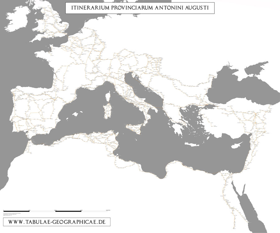
The map is based on Bernd Löhberg's dissertation about the Itinerarium Antonini. As part of his work he offered localizations for each station, modern place names corresponding or at least very close to the Roman toponyms. While Löhberg's book includes its own maps, an overview without stations and a series of detailed route maps based on the Barrington Atlas, a fully digital variant was required.
This was used as the foundation for a digital model of the Roman Empire's traffic network on which we could simulate the spread of the Antonine Plague and visualize the results, a project a friend and me were working on in 2010/2011.
At first we tried to automatically gather the coordinates for each station from modern gazeteers. A method that worked decently well within Europe, but in most cases failed to deliver any useful matches in the African and Near Eastern territories of the Imperium Romanum, in large parts due to the non unified transcription of Arabic place names into Latin script. At the end many stations had to be manually located or their location corrected with the help of the aerial images and cartographic information accessible through Google Earth.
As demonstrated by the map, the routes from the Antonine Itinerary do not cover the entire Roman road network and leave out many important, densely populated areas, as almost the entire province of Asia. Thus, for the simulation these gaps needed to be closed and our network had to be supplemented by adding multiple additional routes with about further 1000 nodes, as well as ports and sea lanes. In this final form it became the starting point for my map Imperium Romanum 211 AD in 2013.

As mentioned above many sections of the road network are part of multiple routes in the itinerary. When viewing the map, it is easily noticed that in many cases single stations are left out, which results in additional lines connecting two places but skipping intermediary stops.
For the next iteration of this map I intend to highlight all different routes found in the Itinerarium Antonini, either by color, line style or a combination of both. Something that wasn't required for our simulation's network and thus is not present in my current data sets.
Bibliography
- Bernd Löhberg, Das Itinerarium provinciarum Antonini Augusti, Frank & Timme, Berlin (2006).
- Konrad Miller, Itineraria Romana römische Reisewege an der Hand der Tabula Peutingeriana, Unveränd. Nachdr. [d. Ausg.] 1916, Bregenz: G. Husslein, (1988).
- Margot Klee, Lebensadern des Imperiums – Strassen im Römischen Weltreich, Theiss (2010).