
Maps of the Roman World
The Roman Empire's world from the beginning of the Principate until the Crisis of the Third Century.


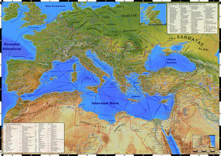

Imperium Romanum 211 AD: A highly detailed, up to date map of the entire Roman Empire from Lower Nubia to the Antonine Wall, with surrounding territories, in the final years of the reign of Septimius Severus, about 211 CE. Scale 1:4.5 Mio., Size DIN A0 (118,9 x 84,1 cm)
Also available in DIN A1 (84,1 x 59,4 cm) as part of the double side poster The World of Ancient Rome.
The Parthian Empire: Detailed map of the Parthian Empire and the Roman Near East in about 64 CE.
Scale 1:4.5 Mio., Size DIN A1 (84,1 x 59,4 cm)
This map is also included on the backside of the double sided poster The World of Ancient Rome.
A version expanded to DIN B1 (100 x 70 cm) is available as The Parthian Empire and the Silk Road
The World of Ancient Rome (double sided): A downscaled version of Imperium Romanum 211 AD, optimized for format DIN A1. The backside shows the entirety of Rome's oriental neighbors, the Parthian Empire, the states around the Red Sea, as wells as ancillary maps of ancient Latium and early 1st century Judea. Scale 1:6 Mio., Size DIN A1 (84,1 x 59,4 cm), double sided
Postcards: As derivatives of my huge wall maps I also created a number of postcards for Sardis Verlag. Available are Imperium Romanum, Etruria et Latium Vetus, Iudaea Provincia and The Parthian Empire.
Size DIN A6 (14,8 x 10,5 cm)
HD prints of this maps can be purchased from my online store.