
Modelling the Antonine Plague
Although I started to collect geo coordinates of ancient sites way back in 2005/2006, this is in many ways the origin of my Roman Empire map. The text on this page comes from a former Sardisverlag.de blogpost, which essentially describes my part in a project to model the spread of the Antonine Plague in the last third of the 2nd century CE. The route network of the Roman Empire created for this project became the starting point of Imperium Romanum 211 AD.
This time we want to show some of our own research which I've already hinted at multiple times, the simulation of the Antonine Plague on the road and sea network of the Roman Empire. In 2010 Daniel and me were attending the annual spring conference of the DPG (German Physical Society) in Regensburg. Part of the conference were several talks from scientists modeling the spread of epidemics on modern transportation networks. Their goal was to further the understanding how to prevent this, but the same methodology could be used to better understand related problems from history. We deiced to try this with the Antonine Plague, a large scale outbreak of smallpox that ravaged the Roman world in the last third of the 2nd century CE.
In the mid 2nd century CE, during the largely peaceful reign of emperor Antoninus Pius, the Roman Empire arguable reached the peak of its military and economic power. After almost two centuries of uninterrupted peace in most parts of the Mediterranean world its cities had grown to unprecedented size and enjoyed their accumulated wealth. With the emperor's death in 161 CE the throne passed to his two adopted sons, his co-regent Marcus Aurelius and Lucius Verus. Shortly thereafter war broke out in the east when the rivaling Parthian Empire invaded Armenia and Roman Syria. The invasion was an initial success and the Roman forces at the Euphrates faced defeat. To stabilize the situation Marcus sent Lucius Verus to the Orient to personally direct the Roman war effort and with him large reinforcements, mostly drawn from the provincial armies along the Rhine and Danube. After five years of fighting the Romans had repulsed the Parthian forces and advance deep into enemy territory. During this phase of the war, while a Roman army was besieging the city of Seleucia at the Tigris, an infectious disease appeared among them for the first time, in modern historiographical literature it is known as the Antonine Plague. When the victorious armies returned they carried the plague with them. In following decades it would ravage through the Empire.
The large number of soldiers withdrawn from Europe to fight the war in the east had seriously weakened the Empire's northern border, a weakness used by several of its Germanic neighbors. After several minor attacks that could be contained through diplomacy or the remaining provincial garrison a full scale war broke out along the western part of the Danubian frontier between Raetia and Dacia in 166 CE. After a peace treaty with the Parthians the Roman armies were now quickly redeployed to the deal with this threat. The first phase of this new war occurred concurrently with the climax of the plague resulting in a collapse of the Roman defenses and serious crisis for the Empire. For the first time in almost 300 years barbarians invaders could penetrate through Pannonia deep into imperial territory finally besieging Aquilea in northern Italy. Great efforts to raise additional money and troops were necessary until the frontier could be secured again and counteroffensives launched across the Danube. With a short interruption this so called Marcommanic wars would continue for rest of Marcus Aurelius reign until his son Commodus could victoriously conclude them in 180/182 CE.
Unlike the many others plagues that routinely swapped across the Mediterranean world it left a rather large footprint in the records of ancient historians, staying in collective memory as an extraordinary event. Until today it is not possible to properly judge the impact of this plague on the Roman Empire. The accounts of contemporary historians such as Cassius Dio detailing the critical years are mostly lost and epigraphic evidence alone is also insufficient. Most sources talking about the Antonine plague are from the late Roman period, written several hundred years after the events and their accuracy is questioned by modern historians. Understanding the impact of the Antonine Plague would help greatly to better understand the economic decline and loss of stability during the reign of Commodus and the Severan era. A large population loss could explain the increased economic difficulties faced by the imperial government and help to interpret the motives behind the Constitutio Antoniana, the beginning of the debasing of the Roman currency with the introduction of the Antoninianus or the multiple massive increases of army pay by Septimius Severus and his son Caracalla.
In older literature it was seen as an almost cataclysmic event, that undermined the once seemingly inexhaustible resources of the Imperium, the first of many steps the would lead to the great crisis of the 3rd century and ultimately the collapse of Roman power in the west 300 years later. More recently there were attempts to use data gathered by archeology to get the plagues footprint, most prominently by Duncan Jones [1]. However this still did not provide us with a clear picture of the plagues effects. While Duncan Jones argued in favor of a devastating impact, studies in other areas did not support his conclusions.
We have seen that when the plague swapped across the Empire, it was engaged in two major wars, first with the Parthian Empire in the east, then with several Germanic and Sarmatian tribes along the upper Danubian frontier and most of Duncan Jones evidence can be equally explained by the economic effects of this conflicts.
A previous attempt to simulate the effects of the plague, published by Yan Zelener in 2003 [2], used more abstract and much simpler models that largely ignored the spatial distribution of the Roman population and neglected the amount of time the epidemic would need to spread throughout the Empire into its remote regions.
With our new approach, using an accurately reproduced traffic network of the Roman Empire in the Antonine era, we hoped to get more detailed and accurate results. Results that could help to finally give answers to some of the following questions:
- A better estimate for population losses in all Roman provinces caused by the plague
- Where the troop movements from the Euphrates back to the Rhine and Danube and also Lucius Verus return to Rome essential for the spread of the plague, as claimed by the Historia Augusta?
- Where all parts of the Empire equally affected, or just some of them as it was speculated in the past?
- Can the recorded later outbreaks of plague all over the Empire be caused by the same illness as it is usually assumed?
Our Network
The first step was to set up our network and how people people travelled along it in the second century. Finally it consisted of nearly 3000 settlements/nodes interconnected by three different kinds of links, representing the road plus short and long range sea transport networks. In the ancient world the volume of traffic was strongly affected by seasons. Especially on sea where the sailing season was largely limited to the brighter months of the year. In our model this is represented by two sinusoidal functions which reduce traffic in winter to 50 % (land) and 10 % (sea) of it's mid summer peak value.

Our road network is based on the Itinerarium Antonini, a third century inventory of roads and mansiones in all parts of the Roman Empire. In its final form it was probably compiled about 284 CE, while still containing older material, but since the Road network was essentially completed in the first half of the 2nd century CE it was a good starting point. Since the Itinerarium Antonini is far from complete and misses routes through some of the most heavily populated provinces and already abandoned territories, that still were under Roman control in 166 CE, it had to be extensively supplemented by additional roads taken form modern historiography and the Tabula Peuntingeriana.
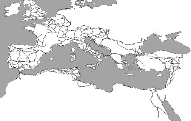
Our network still maintains the basic format of an itinerary, a list of way stations and the distances between them. In the Itinerarium this way stations could be everything from large cities to a simple mansio somewhere in the countryside. Usually they are placed one day's march or about 30 kilometers apart from each other. For our purposes all were categorized based on the expected population density of their environment, estimated from the number of nearby sites included in the Barrington Atlas. We defined five categories, one for great urban centers of the Empire, the next for ordinary large cities and rural areas with exceptional high population density, as the Nile valley with its estimated 200 people per square km, which is more than ten times the number found in western European provinces. Two categories were destined to represent highly or sparsely settled ordinary rural areas and their towns. Finally the last category was made for simple way stations in nearly unpopulated regions, such as the hydreumata along the desert roads. For the simulation the Empire's total population was distributed among all 2985 nodes based on this categories. For exceptional nodes, like Roma with it's one million inhabitants, we included the capability to alternatively define exact population numbers.
Around the Mediterranean ships were the primary method of traveling, thus the maritime networks had to be implemented as well. As a first step 352 nodes were defined as ports and if necessary connected to the road network. For this we used the Lehmann-Hartleben catalog and supplemented it by more modern publications and ports around other seas.
Our short range sea transport network simulates local, mainly coast hugging traffic with smaller ships. This network was automatically generated by connecting all ports within a defined distance with each other. Since this resulted only in distances as the crow flies we set the speed of these vessels to 3 knots, the lower average for ancient merchantmen in adverse conditions.
The long distance sea network consists of major routes between the great maritime hubs of the Roman Empire. Traffic along this routes was usually handled by larger vessels. Thus the ships in our model carry 30 persons instead of the 10 in the short distance network. Unlike the short distance and road network this part was not assembled from distances, but includes directly the travel times between ports. These were taken from ancient sources as evaluated and compiled by modern scholars, mainly from the works of Lionel Casson. His 1951 article Speed under Sail of Ancient Ships is available online, the updated and expanded material is part also part of his 1995 book Ships and Seamanship in the Ancient World [3]. In the next posts (that were never written) we will explain our model of the actual epidemic and present some of the results.
Additional literature
[1] Richard. Duncan-Jones, The Impact of the Antonine Plague, Journal of Roman Archaeology 9 (1996), 108–136.
[2] Yan Zelener, Smallpox and the Disintegration of the Roman Economy after 165 AD, PhD Thesis, Columbia University, 2003.
[3] Lionel Casson, Ships and Seamanship in the Ancient World. The Johns Hopkins University Press 1995.