
Classical Greece and its Neighbors
Highly detailed, large scale map of ancient Greece and surrounding territories in the 5th and 4th centuries BCE. The map depicts the political situation in about 431 BCE, shortly before the outbreak of the Peloponnesian War.
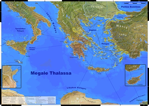
Features:
- All territories affected by the Peloponnesian and Greco-Punic wars,
-
The Delian and Peloponnesian leagues,
-
All other states with their respective subdivisions, as well as 50 tribes and peoples,
-
Major land and sea routes,
-
More than 850 settlements,
-
More than 80 sanctuaries,
-
Important mines and quarries,
- Forts and Fortifications,
-
More than 80 regions,
-
More than 140 other toponyms, like islands, mountain ranges or seas,
- Geodata modified to correctly portray the world of Classical Greece,
- Legend in English and German,
-
Scale 1:1.500.000,
-
Format: DIN A0 (118,9 x 84,1 cm).
HD prints of this map can be purchased from my online store. There, it is also available in two digital versions. Either as full sized map or as smaller DIN A1 (84,1 x 59,4 cm) sized excerpt.


Commentary - Classical Greece and its Neighbors
Despite the map focusing on the era of the Delian league and the Peloponnesian War in the latter half of the 5th century BCE, it should also be suited to cover the entire classical period in this part of the world. Thus 4th century BCE settlements and sanctuaries were added and the coverage expanded, to include regions relevant for the soon following rise of Macedon and Rome, but especially also Carthage in west. There, the entire 4th century was dominated by conflicts between the Sicilian Greeks and their Punic neighbors, with war erupting again and again.
Again, the map should provide a view of the Mediterranean as seen from space. Thus for the background I combined landclass and bathymetry data from
Natural Earth with a shaded relief. Compared to my previous maps, the greater scale of
1:1.5 million required many additions and enhancements of the base data.
A greater number of additional rivers and islands were added and existing coastlines improved when necessary. At places where the coastline has changed significantly since ancient times, the geoadata was accordingly modified. A higher resolution of the shaded relief was also desirable and achieved by recalculating it from the EarthEnv-DEM90 digital elevation model [1]. The map uses an Universal Transverse Mercator projection, UTM Zone 34N, EPSG 32634, optimal for Greece.
Settlements and Sanctuaries
The 4th century places marked on the map are explicitly towns and sanctuaries (re)established in this century. It is not the date of their first
appearance in our sources. This includes settlements like Philippopolis/Plovdiv, which despite being built on site of an older Thracian predecessor, was as a new Macedonian Polis, receiving a
significant number of new colonists.
Especially in inland Italy or Asia minor numerous cities are only mentioned, or begin to produce epigraphic material, in Hellenistic or Roman times, but according to archaeology existed already
long before that date. In most cases a continuous, uninterrupted tradition can be assumed, thus they are not distinguished on the map.
In the classical period and beyond inland Asia Minor also was a mostly rural space with very few urban centers. Only later this should change, as Hellenistic and Roman governments begun to pursuit a long term policy of urbanizing the interior. Thus it should not be expected that the places marked on the map already had a comparable appearance to the coastal cities, although in most cases admittingly not much is known about them during this era [2].
In the border zones of Greece‘s cultural sphere, like Caria, Lycia or Pamphylia, many cities had a mixed Greek and native population. The gradual
assimilation process into fully Greek cities sometimes took centuries to complete. Thus usually no precise dates can be given when exactly they became Greek Poleis. For their classification I
orientated myself on the detailed data collected by The Copenhagen Polis Centre for each city [3].
Generally, if a city on the map is distinguished as a Polis, it only refers to the city’s political structure, not their ethnic composition.
In some cases it is hard to decide if a settlement should be marked as a sanctuary or city. One example is, as the name already indicates, Hierakome with the sanctuary of Artemis Persike in Lydia. The cult became very prominent in later times and can already be traced back at least to the 4th century. However the place produces also older Lydian era finds. Was later Hierakome originally a settlement which cult became prominent or begun as a rural sanctuary which developed into a considerable settlement? A question that can’t be answered conclusively without excavation on the site [4].
Borders
As far as possible the map depicts the political situation in the last decade before eruption of the Peloponnesian War, about 440 to 431 BCE.
At least currently, it is in many cases not always possible to trace the borders of the numerous city states with some accuracy at all. For others we can only determine their traditionally held
territory, but not the precise borderline at a fixed date, like 431 BCE.
Forts
Following the maps philosophy outlined above, I also included 4th century forts on the map. Here too, often the sites are not, or can’t be dated
exactly. As a matter of debate it seems likely that especially the hillforts in Samnium and other areas of central Italy only originated during the era of conflict between the rising Roman
Republic and the local tribes in the 4th century.
Just as the heavily fortified land frontier in northern Attica in its final form, which is depicted on the map, was only created as reaction to the experiences of the Peloponnesian War
[5].
The Delian League
The Delian League is divided into five Phoros (tribute) districts as they existed until 437 BCE [6]. Not included are allies and member states that most likely only entered Athens league during the course of the Peloponnesian War. Islands like Anaphe, Pholegandros, Sikinos and Thera, for which it was suggested that it was Lysicles expedition of 12 ships in 428 BCE [7] that brought them into Athens sphere of influence or Kephallenia, whose loyalty had to be secured by an military expedition during the initial phase of the conflict [8].
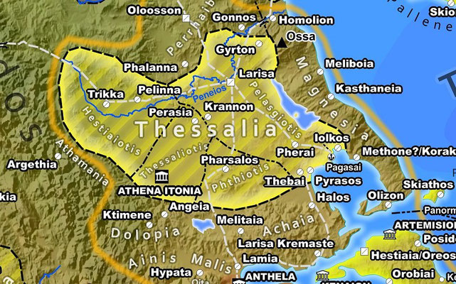
Thessaly
Thessaly was surrounded by a number of regions, namely Dolopia, Ainis, Oita, Achaia, Magnesia, Perrhaibia and later Athamania, that were eventually subjugated by the Thessalians and integrated into their state. However during the classical period they were still separate polities, capable of pursuing their own agenda, even if nominally already Thessalian dependencies. In Thucydides too, only contingents of Thessalian troops fighting for the Athenian side from Thessaly proper are mentioned. Thus Thessaly its dependencies and surrounding regions are represented accordingly on the map.
Macedon-Thrace
In 432/431 BCE the political situation in the Macedonian-thracian border zone changed very dynamically. Olynthos and a further number of Chalkidian cities had revolted from Athens, which was waging war against Macedon. There, according to the philosophy behind the map, long term allegiance to the Delian League takes preeminence over depicting the momentary political situation. The Poleis of Therme and Methone most likely both came under Athenian control in 432/431. However, the former was already returned to Perdikkas in summer 431 [9], while Methone became a member of the Delian league and appears in the Athenian tribute list several times until 415/14.
Cyprus
What was said above about the difficulties of deciding about the Polis status of cities is especially true for the city kingdoms of Cyprus. Since the Bronze Age collapse the island had been a
melting pot of various cultures, Greeks, Phoenicians, native Cyprian and their changing eastern overlords. Before the kingdoms were disestablished early under Ptolemaic rule, their central cities
were rarely explicitly called a Polis by contemporary authors and also epigraphically only once among hundreds of inscriptions the inland city of Idalion [10].
On the map the Vouni palace is marked as the seat of a Persian governor, possibly installed after the islands participation in the Ionian revolt. This is not the only discussed function of this
structure. Alternatives, such as an outpost of the pro Persian of Marion have also been suggested [11].
Royal Roads
Regarding the Persian Royal Roads, i.e. the routes served by the royal postal service (Pirradaziš), it has to be said that even for the better-known segments, the exact route often can only be estimated. Generally, the available evidence, such as the Persepolis tablets, allows us only to firmly reconstruct their origin and destination. The exact path, however, can only ever be speculative.
Footnotes:
[1] Natalie Robinson and the NCEAS Environment and Organisms (ENO) Working Group http://www.earthenv.org/DEM.html, CC BY 4.0 https://creativecommons.org/licenses/by/4.0/.
[2] In detail Marek 2010 or for archaic and classical Lydia especially, Roosevelt 2014
[3] Hansen et. Al. 2005
[4] Roosevelt 2014
[5] Ober 1985, for Italy the respective contributions in Farney, G. Bradley 2016
[6] Ruschenbusch 1977
[7] Thuc. 3.19
[8] Thuc. 2.30
[9] Thuc. 2.29
[10] Hansen et. Al. 2005
[11] Schollmeyer 2009
Bibliography
The literature consulted by me when making the Classical Greece map. For better readability, the list of sources is separated by topic into sections. We begin with a list of more general topics, then continue with three geographical subdivisions: Achaemenid Asia and Egypt, Greece, including the entire Aegean, and the Balkan Peninsula and finally the West - Italy, Sicily and North Africa.
Primary Sources
- Herodot (ca. 484 - 425 BCE): Histories
- Thukydides (ca. 454 - 399-396 BCE): Ἱστορίαι
- Xenophon (ca. 430 - 354 BCE): Anabasis
- Arrian (ca. 85–90 - 145/146 CE): Anabasis of Alexander, Indica
- Strabo (ca. 63 - 23 CE): Geographica
General
- BOARDMAN 1982: J. Boardman, N.G.L. Hammond (eds.), The Cambridge Ancient History 2nd edition Volume 3.3. The Expansion of the Greek World, Eighth to Sixth Centuries B.C., Seventh Printing, Cambridge University Press (2006).
- BOARDMAN 1988: J. Boardman, N.G.L. Hammond, D.M.Lewis, M. Ostwald (eds.), The Cambridge Ancient History 2nd edition Volume 4. Persia, Greece and the Western Mediterranean C. 525 to 479 B.C., Sixth Printing, Cambridge University Press (2006).
- CASSON 1995: L. Casson, Ships and Seamanship in the ancient world, Johns Hopkins University Press (1995).
- HANSEN 2005: M. H. Hansen, Th. H. Nielsen, An Inventory of Archaic and Classical Poleis. An Investigation Conducted by The Copenhagen Polis Centre for the Danish National Research Foundation., Oxford University Press, (2005).
- HORNBLOWER 2011: S. Hornblower, The Greek World 479-323 BC, Routledge History of the Ancient World, Routledge, 4th Revised edition (2011)
- MORTON 2001: J. Morton, The Role of the Physical Environment in Ancient Greek Seafaring, Mnemosyne, Bibliotheca Classica Batava Book 213, Brill (2001).
- PLEIADES: B. Turner, T. Elliott et. Al., Pleiades - A community-built gazetteer and graph of ancient places, http://pleiades.stoa.org
- ROHDE 2016: D. Rohde, Dorothea, M. Sommer, Wirtschaft, Geschichte in Quellen - Antike, wbg Academic (2016).
- STILLWELL 1976: R. Stillwell, W. L. MacDonald, L. William, M. H. McAlister, The Princeton encyclopedia of classical sites, N.J. Princeton University Press (1976).
- TALBERT 2000: R.J.A. Talbert (ed.), Barrington Atlas of the Greek and Roman World, Princeton University Press (2000).
- TAVO, Tübinger Atlas des Vorderen Orients, Dr. Ludwig Reichert Verlag (1975-1993).
- TOPOSTEXT: B. Kiesling (ed.), Topostext - An indexed collection of ancient texts and mapped places relevant to the history and mythology of the ancient Greeks, https://topostext.org/
- WBG 2024: M. Blömer, A. Lichtenberger (eds.), Erhaben und den Göttern nahe - "Heilige Berge" der Antike, wbg Philipp von Zabern, Verlag Herder (2024).
- WITTKE 2007: Anne-Maria Wittke, Eckart Olshausen, Richard Szydlak, Der neue Pauly. Historischer Atlas der antiken Welt, Metzler (2007).
Geodata
- Höhenmodell berechnet aus EarthEnv-DEM90 digital elevation model, Natalie Robinson and the NCEAS Environment and Organisms (ENO) Working Group http://www.earthenv.org/DEM.html, CC BY 4.0 https://creativecommons.org/licenses/by/4.0/.
- Original coastlines and bathymetry: naturalearthdata.com
Achaemenid Asia and Egypt
- AAP 2015: S. James, V. Score, Dreamer’s Bay excavation and survey, September 2015 Interim Report, Ancient Akrotiri Project, University of Leicester (2015) https://www2.le.ac.uk/departments/archaeology/research/projects/ancient-akrotiri.
- AAP 2016: S. James, V. Score, Dreamer’s Bay excavation and survey, September 2016 Interim Report, Ancient Akrotiri Project, University of Leicester (2016) https://www2.le.ac.uk/departments/archaeology/research/projects/ancient-akrotiri.
- AAP 2017: S. James, V. Score (eds.), Dreamer’s Bay (Nisarouin) excavation and survey, 2017 Interim Report, Ancient Akrotiri Project, University of Leicester (2017) https://www2.le.ac.uk/departments/archaeology/research/projects/ancient-akrotiri.
- BRIANT 2002: P. Briant, From Cyrus to Alexander A History of the Persian Empire, Eisenbrauns (2002).
- BRYCE 2009: T. Bryce, The Routledge Handbook of the Peoples and Places of Ancient Western Asia: The Near East from the Early Bronze Age to the Fall of the Persian Empire, Routledge (2009).
- COLBURN 2013: H. P. Colburn, Connectivity and Communication in the Achaemenid Empire, Journal of the Economic and Social History of the Orient 56 (2013), 29-52.
- FLAUX 2017: C. Flaux, M. El-Assal, C. Shaalan, N. Marriner, C. Morhange, M. Torab, J.-Ph. Goiran, J.-Y. Empereur, Geoarchaeology of Portus Mareoticus: Ancient Alexandria's lake harbour (Nile Delta, Egypt), Journal of Archaeological Science: Reports 13 (2017), 669–681.
- GODDIO 2011: F. Goddio, Heracleion-Thonis and Alexandria, two ancient Egyptian emporia, in D. Robinson, A. Wilson (eds.), Maritime Archaeology and Ancient Trade in the Mediterranean, Oxford Centre for Maritime Archaeology (2011).
- JOHNSON 2010: P.A. Johnson, Landscapes of Achaemenid Paphlagonia, Dissertation, University of Pennsylvania (2010).
- KHATCHADOURIAN 2012: L. Khatchadourian, The Achaemenid Provinces in Archaeological Perspective, in D.T. Potts (ed.), A Companion to the Archaeology of the Ancient Near East, Blackwell Publishing (2012).
- KUHRT 2009: A. Kuhrt, The Persian Empire: A Corpus of Sources from the Achaemenid Period, Routledge (2009).
- LIVIUS: J. Lendering, http://www.livius.org/, (1996-2019).
- MAREK 2010: C. Marek, P. Frei, Geschichte Kleinasiens in der Antike, 2. durchges. Aufl., C.H. Beck (2010).
- MUÑOZ 2013: J. V. Muñoz, Las estaciones reales durante el periodo Aqueménida/The Royal Stations in the Achaemenid Period, LVCENTVM XXXII (2013), 185-203.
- ROOSEVELT 2009: C. H. Roosevelt, The Archaeology of Lydia, from Gyges to Alexander, Cambridge University Press (2014).
- SCHOLLMEYER 2009: P. Schollmeyer, Das antike Zypern: Aphrodites Insel zwischen Orient und Okzident, von Zabern (2009).
- SEIBERT 2002: J. Seibert, Unterwegs auf den Straßen Persiens zur Zeit der Achämeniden, Iranistik 1 (2002), 7–40.
- SOMMER 2008: M. Sommer, Die Phönizier: Geschichte und Kultur, C.H.Beck (2008).
- WATERS 2014: M. Waters, Ancient Persia: A Concise History Of The Achaemenid Empire, 550–330 BCE, Cambridge University Press (2014).
- WEISKOPF 1982: M. N. Weiskopf, Achaemenid systems of governing in Anatolia, Ph.D. diss., University of California (1982).
- WEISKOPF 1989: M. N. Weiskopf, The so-called "Great Satraps' Revolt", 366-360 B.C.: Concerning Local Instability in the Achaemenid far West, Franz Steiner Verlag (1989).
Greece, Aegean and Balkan Peninsula
- BATLRUSCH 2003: E. Baltrusch, Sparta: Geschichte, Gesellschaft, Kultur C.H.Beck, 2.überarbeitete Auflage (2003).
- BECK 2013: H. Beck (ed.), A Companion to Ancient Greek Government, Wiley-Blackwell (2013).
- BECK 2015: H. Beck, P. Funke (eds.), Federalism in Greek Antiquity, Cambridge University Press (2015).
- BORBEIN 1995: A.H. Borbein (ed.), Das alte Griechenland. Kunst und Geschichte der Hellenen, Bertelsmann (1995).
- BREDOW 2002: I. von Bredow. Die Handelsverbindungen zwischen Pontos und Agais zur Zeit des Odrysenreiches, in E. Olshausen, H. Sonnabend (Hrsg.) Stuttgarter Kolloquium Zur Historischen Geographie Des Altertums 7, 1999: Zu Wasser Und Zu Land. Verkehrswege in Der Antiken Welt, Franz Steiner Geographica Historica 17 (2002).
- BÜLOW 2008: G. von Bülow, R. Ivanov, Thracia: Eine römische Provinz auf der Balkanhalbinsel, Philipp von Zabern (2008).
- BURKHARDT 2012: N. Burkhardt, F. Daubner, Von Pfahlbauern zu Bischöfen - Antike Stätten in Nordmakedonien, Antike Welt 04/2012, Phillip von Zabern (2012), 75-83.
- CHANIOTIS 2014: A. Chaniotis, Das antike Kreta, C.H.Beck, 2. Auflage (2014).
- DANOV 1976: C. Danov, Altthrakien, De Gruyter (1976).
- FOL 2004: A. Fol, V. Fol , K. Jordanov, G. Kitov, L. Konova et Al., Die Thraker. Das goldene Reich des Orpheus, Phillip von Zabern (2004).
- FREITAG 2001: K. Freitag, P. Funke, Kult, Politik, Ethnos: überregionale Heiligtümer im Spannungsfeld von Kult und Politik, Kolloquium, Münster, 23.-24. November 2001, Steiner (2006).
- GOETTE 2008: H. R. Goette, Athens, Attica and the Megarid: An Archaeological Guide, Routledge (2008).
- GOETTE 1991: H. R. Goette, Die Steinbrüche von Sounion im Agrileza-Tal, Athenische Mitteilungen 106 (1991), 201-222.
- GSCHNITZER 2002: F. Gschnitzer, Straßen, Wege und Märsche in Xenophons Hellenika. Ein Beitrag zur Verkehrsgeographie Griechenlands in klassischer Zeit, in E. Olshausen, H. Sonnabend (Hrsg.)Stuttgarter Kolloquium Zur Historischen Geographie Des Altertums 7, 1999: Zu Wasser Und Zu Land. Verkehrswege in Der Antiken Welt, Franz Steiner Geographica Historica 17 (2002).
- IREN 2013: K. Iren, Aiolis, in R. S. Bagnall, K. Brodersen, C. B. Champion, A. Erskine, and S. R. Huebner, The Encyclopedia of Ancient History, First Edition (2013), 246–248.
- IZDIMIRSKI 2015: M. Izdimirski, Boryza - a Persian Polis in Ancient Thrace, in Proceedings of International Conference: Iran and Bulgaria in the Mirror of History (Past, Present, Future) (2015), 131-138.
- KANINIA 2017: E. Kaninia, S. Schierup, Vroulia revisited - From K. F. Kinch’s excavations in the early 20th century to the present archaeological site, Proceedings of the Danish Institute at Athens, vol. VIII (2017), 89-129.
- KISSAS 2018: K. Kissas, Die Kouroi von Tenea - Die Entdeckung der Nekropole von Klenia, Antike Welt 01/2018, Phillip von Zabern (2018), 45-51.
- LOHMANN 2002: H. Lohmann. Antike Straßen und Saumpfade in Attika und der Megaris, in E. Olshausen, H. Sonnabend (Hrsg.)Stuttgarter Kolloquium Zur Historischen Geographie Des Altertums 7, 1999: Zu Wasser Und Zu Land. Verkehrswege in Der Antiken Welt, Franz Steiner Geographica Historica 17 (2002).
- MORENO 2008: A. Moreno, HIERON - The Ancient Sanctuary at the Mouth of the Black Sea, Hesperia 77 (2OO8), 655-709.
- OBER 1985: J. Ober, Fortress Attica: Defense of the Athenian Land Frontier 404-322 B.C, Mnemosyne Vol Suppl. 84, Brill (1985).
- OPPERMAN 2007: M. Oppermann, Thraker, Griechen und Römer: An der Westküste des Schwarzen Meeres, Philipp von Zabern (2007).
- SANADER 2007: M. Sanader, Kroatien in der Antike, Philipp von Zabern (2007).
- RUSCHENBUSCH 1977: Eberhard Ruschenbusch, Zur Zahl der Tributbezirke des delischen Seebundes und zur Datierung des Kleinias- und des Münzdekrets (Meiggs-Lewis 45 und 46), Zeitschrift für Papyrologie und Epigraphik Bd. 26 (1977), 211-215.
- TAUSEND 1992: K. Tausend, Amphiktyonie und Symmachie: Formen zwischenstaatlicher Beziehungen im archaischen Griechenland, Franz Steiner Verlag (1992).
- TAUSEND 2006: K. Tausend, Verkehrswege der Argolis. Rekonstruktion und historische Bedeutung, F. Steiner (2006).
- UJES 2009: D. Ujes Morgan, The pattern of Findspots of Coins of Damastion - the Clue to Its Location, in N. Holmes (ed.), Proceedings of the XIVth International Numismatic Congress, Glasgow, 2009 (2011), 487-496.
- WAGNER 2018: M. Wagner, Auf der Suche nach Artemis - Die Entdeckung des Heiligtums der Artemis Amarysia, Antike Welt 04/2018, Phillip von Zabern (2018), 52-63.
- WBG 2025: Jasper Tae Jensen (ed.), Die Kykladen - Wiege frühgriechischer Kultur, wbg Philipp von Zabern, Verlag Herder (2025).
- WEBBER 2001: C. Webber, A. McBride, The Thracians 700 BC-AD 46, Men-at-Arms No. 360, Osprey Publishing (2001).
- WIRBELAUER 2002: E. Wirbelhauer. Landesgeschichte als Meeresgeschichte. Antike Seerouten und Seefahrten im der mittleren Ionischen Inseln, in E. Olshausen, H. Sonnabend (Hrsg.) Stuttgarter Kolloquium Zur Historischen Geographie Des Altertums 7, 1999: Zu Wasser Und Zu Land. Verkehrswege in Der Antiken Welt, Franz Steiner Geographica Historica 17 (2002).
- WÜST 1954: F. R. Wüst, Amphiktyonie, Eidgenossenschaft, Symmachie, in Historia: Zeitschrift für Alte Geschichte Bd. 3, H. 2 (1954), 129-153.
The West - Italy, Sicily and North Africa
- ATTEMA 2014: P. Attema, T. de Haas, M. Termeer, Early colonization in the Pontine region (Central Italy), in: T.D. Stek & J. Pelgrom (eds), Roman Republican Colonization - New Perspectives from Archeaology and Ancient History, Papers of the Royal Netherlands Institute in Rome, vol. 62 (2014), 211-232.
- BAKKUM 2009: G.C.L.M. Bakkum, The Latin dialect of the Ager Faliscus: 150 years of scholarship, Amsterdam University Press (2009).
- BUBENHEIMER 2014: F. Bubenheimer-Erhart, Die Etrusker, Phillip von Zabern (2014).
- CAMPOREALE 2003: G. Camporeale, Die Etrusker. Geschichte und Kultur, Artemis & Winkler (2003).
- CARDONA 2024: D. Cardona, Ein Knotenpunkt im Mittelmeer - Das phönizische und punische Malta, Antike Welt 04/2024, Verlag Herder (2024), 19-22.
- CORNELL 1995: T. Cornell, The Beginnings of Rome: Italy and Rome from the Bronze Age to the Punic Wars (C. 1000-264 BC), Routledge History of the Ancient World (1995).
- DE HAAS 2011: T. de Haas, Fields, farms and colonists. Intensive field survey and early Roman colonization in the Pontine region, central Italy, Barkhuis as Groningen Archaeological Studies vol. 15 (2011).
- FARNEY 2016: G.D. Farney, G. Bradley (Eds.), The Peoples of Ancient Italy, De Gruyter Reference (2016).
- GOODCHILD 1954: R. G. Goodchild, Arae Philaenorum and Automalax, Papers of the British School at Rome Vol. 20 (1952), 94-110.
- HELLE 2002: W. H.Helle, The Cultural Development in North Western Lucania C. 600-273 BC, Analecta Romana Instituti Danici. Supplementa 28, L'Erma di Bretschneider (2002).
- HEMPHILL 1970: P. Hemphill, An Archaeological Survey of Southern Etruria, Expedition vol. 12.2 (1970), 31-39.
- HOYOS 2010: D. Hoyos, The Carthaginians (Peoples of the Ancient World), Routledge (2010).
- HUSS 2000: W. Huß, Karthago, C.H.Beck, 2. durchgesehene Auflage (2000).
- KENRICK 2013: P. Kenrick, Cyrenaica (Libya Archaeological Guides), Silphium Press (2013).
- PLEUGER 2019: E. Pleuger, J.-Ph. Goiran, I. Mazzini, H. Delile, A. Abichou, A. Gadhoum, H. Djerbi, N. Piotrowska, A. Wilson, E. Fentress, I. Ben Jerbania, N. Fagel, Palaeogeographical and palaeoenvironmental reconstruction of the Medjerda delta (Tunisia) during the Holocene, Quaternary Science Reviews 220 (2019,) 263-278.
- PRAYON 2003: F. Prayon, Die Etrusker: Geschichte - Religion - Kunst, C.H.Beck, 3. durchgesehene Auflage (2003).
- SALIMBETI 2014: A. Salimbeti, R. D’Amato, The Carthaginians 6th–2nd Century BC, Elite No. 201, Osprey Publishing (2014).