
During the last moths I could resume work on the Bronze Age map which has progressed well. Despite the considerable work already done for the Ancient Egypt map, this will be a long project. Hopefully, it can be finished during the course of winter, but more likely it will be summer again before the new map is ready for printing. The focus is currently on the two major powers of Mesopotamia, the Middle Assyrian kingdom and Kassite Babylonia, as well as the landscape they inhabited. The next steps will be Elam and the Hittite Empire. Once the major framework is complete, thus all great powers of the era are on the map and the Bronze Age landscape is reconstructed, I will focus on minor actors in the surrounding territories and especially the long distance trade networks. An additional smaller scale ancillary map will give a wider picture, including far away places like Cornwall and Afghanistan from where essential tin and exotic goods like Lapis Lazuli were transported to the Middle east.
Despite being mainly planned as a map of the Late Bronze Age, with political borders reflecting the situation in about 1250 BCE, it will also feature earlier sites. Whenever possible the map will include famous and not so famous cities, mines or quarries already abandoned during the Early or Middle Bronze Ages.
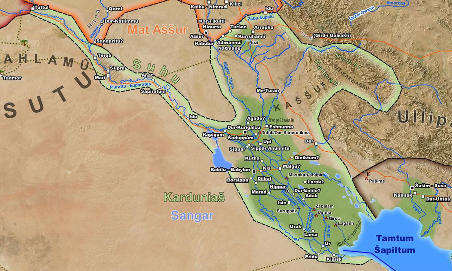
Work in Progress: Southern Mesopotamia in the Late Bronze Age
In Babylonia, the almost 400 years of Kassite rule was so far the politically most stable period in its long history, stretching already back for more the 2000 years. Karduniash, a term originally denoting just the territory ruled by the first Kassite kings, similar to Imperium Romanum more than a millennium alter, became synonymous with the entire country, formerly only known as Sumer and Akkad. The former was already in decline since the end of the Old Babylonian period and an entire string of ancient Sumerian cities was abandoned. They all have in common that they once were located at or the near the main branch of the Tigris.
One big aspect of the new map is reconstructing the ancient landscape. The last 6000 years saw not only the rise and fall of countless regimes and entire civilizations, but also significant changes to their environment. Millennia of natural change and Human interaction, changing watercourses, deposition and erosion of soils, have created a very complex landscape, now slowly deciphered by modern science. A recent study (Jotheri 2016) could identify 11 avulsions of the Tigris (5), Euphrates (4), Diyala (1) and Adhaim (1) in the last 7000 years.

The meandering Arahtum palaeochannel, approaching Eridu from the north-east, can clearly be seen in 1984 satellite imagery from Google Earth. Even if mapping such channels can today be done rather easily, dating them requires to examine sediments or excavating sites along their course.
Originally, the main branch of the Tigris ran through the center of the alluvial plain and its waters could be used for irrigating large tracts of land, until it shifted eastwards at some point in the second millennium BCE. The modern channel of the river, at least between Baghdad and Kut, is lower-lying than the surrounding land, thus in Parthian and Sassanian times its use for irrigation was mainly as a drainage for excess water from canals coming from the Euphrates in the west or the Nahrawan canal in the east.
When this shift happened can’t be dated precisely. Most likely both branches were simultaneously active for some time. In a Kassite period letter from Nippur, located north of the abandoned cities on the old Tigris course, the river is still named as a source for irrigation water close to the city. A similar situation is better documented for the Roman era Euphrates. Since about 125 BC the river split just to the north of Babylon, most of the water was now running through the new Sura branch, following the course of the old man made Bar Nanitu canal towards Kish, meeting the Tigris north of modern Kut. However, the the old Arahtum branch, running southwards through Babylon towards the Gulf, still received some water, but didn’t reach the sea anymore, instead ending in the swamps of southern Mesopotamia instead (Pliny NH V.21).

SRTM derived height data. The present course of the Tigris is clearly visible in the East, an older bed with ancient sites arrayed alongside its banks in the west. Once the approximate course of an ancient channel active during the map's period is securely identified from literature (red line), such data can be used to get accurate and naturally looking vector data for the map. The shift between both channels happened in the 13th century AD.
Bibliography
- P.-A. Beaulieu, A History of Babylon, 2200 BC - AD 75, Blackwell History of the Ancient World, John Wiley and Sons Ltd (2018)
- R. D. Biggs, A Letter from Kassite Nippur, Journal of Cuneiform Studies Vol. 19, No. 4 (1965), 95-102.
- H. Gasche, M. Tanret, S. W.Cole, K. Verhoeven, Fleuves du temps et de la vie. Permanence et instabilité du réseau fluviatile babylonien entre 2500 et 1500 avant notre ère, in Annales. Histoire, Sciences Sociales. 57ᵉ année, N. 3 (2002), 531-544.
- J. Hamza Abdulhussein Jotheri, Holocene avulsion history of the Euphrates and Tigris rivers in the Mesopotamian Floodplain, Durham theses, Durham University (2016), http://etheses.dur.ac.uk/11752/
- V. M. A. Heyvaert, C. Baeteman, A Middle to Late Holocene avulsion history of the Euphrates river: a case study from Tell ed-Der, Iraq, Lower Mesopotamia, Quaternary Science Reviews 27 (2008), 2401–2410.
- J. Pournellein, Physical Geography of the Sumerian World, in H. Crawford (ed.), The Sumerian World, Routledge (2012), 13-33,
- P. Steinkeller, New Light on the Hydrology and Topography of Southern Babylonia in the Third Millennium, Zeitschrift für Assyriologie und Vorderasiatische Archäologie, Volume 91, Issue 1 (2001), 22–84.
Write a comment