
To quicker increase our product portfolio, Sardis Verlag released a number of DIN A6 sized postcards (14,8 x 10,5 cm), either with unique content or as scaled down versions of the big wall maps. Usually the latter were accompanied by a corresponding postcard a few weeks later. Although I really liked these miniaturized maps, the practice stopped with my map of Ancient Egypt and the termination of Sardis Verlag in 2017, in favor of more large scale maps like Classical Greece. Now, with my other Ancient world map projects released over the course of the last year, the time has come to finish the once planned Ancient Egypt postcard too.
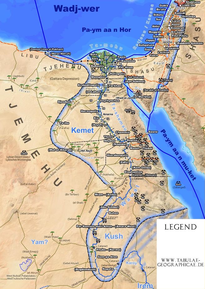
Work in Progress: The miniaturized version of my map of Ancient Egypt. Downsized from DIN B1 (70 x 100 cm) to DIN A6 (14,8 x 10,5 cm). Yet without a consistent naming scheme. Scale 1:13 Million
Ever since the first edition of my Roman Empire map, all of my maps maps were intended to be as independent from modern languages as possible. Usually by using contemporary terms for labels on the actual map canvas wherever possible and limiting modern ones to the legend. Thus greatly simplifying things by only having a single project in QGIS that has to be maintained and a single set of prints that can be distributed and sold internationally.
This approach worked well for Roman Empire era maps, where Latin could be used for labels and names generally look familiar to the modern eye. For my others maps it met its limitations. Especially on the Bronze Age maps, where more arcane languages as ancient Egyptian had to be used, that were never intended to be written with Latin letters. The original map of Ancient Egypt has an extensive legend that translates all Egyptian terms and comes with a booklet that lists all settlements including their more familiar classical and modern era names.
For the postcard another approach has to be chosen. Ideally, on the small canvas, everything should be self explaining, without need for an extensive legend, for which the space simply can't be devoted. Also, unlike my larges scale wall maps, a postcard is intended for a more general audience which only emphasizes the last point.
This is where the work is paused right now. There are basically three option or a combination of them:
- Keep ancient Egyptian names for flavor. I.e. Ta-shemau for Upper Egypt
- Use classical, Latin names. I.e. Aegyptus superior for Upper Egypt
- Use modern names, or more precisely the names commonly used today, since some sites are predominantly known by their Greek or Roman names, others by modern denominations.
The image shows the current state of the map, yet without a consistent naming scheme.
Write a comment