
Two new maps are finally ready for public release, The Bronze Age World and The Parthian Empire and the Silkroad. Both are now available as download version and present on their respective preview pages. While custom made prints such as on canvas are also possible, a regular paper edition is currently only scheduled for late summer or fall.
The Bronze Age World: A completely new highly detailed wall map of the great civilizations of the Middle east and their world in the late Bronze Age, sized DIN A0 (118,9 x 84,1 cm). The map depicts the political situation in about 1250 BCE, but also includes abandoned sites, lakes and river courses from earlier periods.
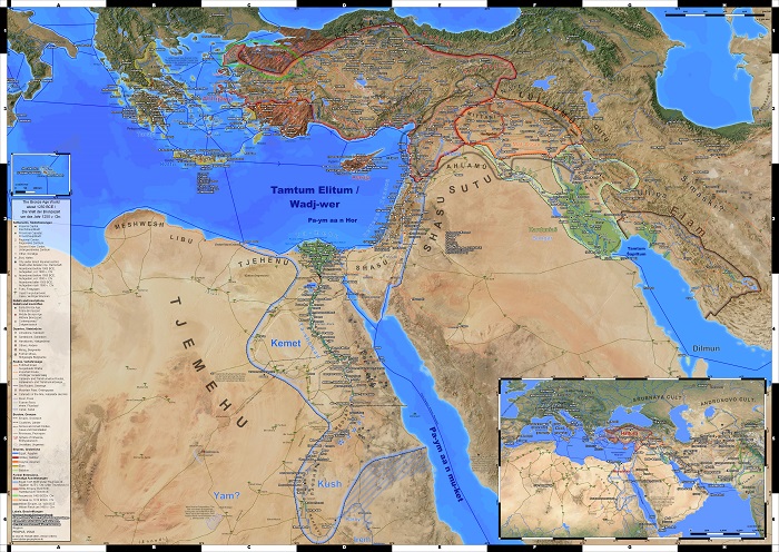
As a last step before release I could made some more changes to the background image last week to fix some visually unpleasant places along the coastlines. With this done the map is, after many years, finally in a state that gives me the confidence to show it to the public in its entirety. Already last fall The Bronze Age World got is own section on this page, now it is also present on the preview page.
Just as all of my maps, I will also continue to develop and supplement The Bronze Age World, to as far as possible include the knowledge gained from latest research and strive for the most detailed map possible within the chosen restrains.
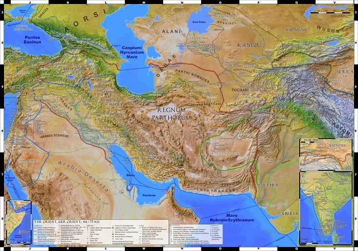
The Parthian Empire and the Silk Road: A new updated and expanded version of my original Parthian Empire map from 2016, enlarged from size DIN A1 (84 x59 cm) to DIN B1 (100 x 70 cm) . With the scale of 1:4.5 million unchanged the additional map area as well as another ancillary map allowed to depict the entire Kushan Empire as well as the course of the ancient Silk Road through the Tarim basin to Chang'an, capital of the Chinese Han dynasty.
While the map was envisioned as a companion to Imperium Romanum 211 AD, which is most evident in the continued zebra frame alpha numerical grid, it actually shows the Middle East and Central Asia in the second half of the 1st century CE, with about 140 years of change ahead until 211 AD. Thus even if the overlap of both maps is significant, the political situation depicted is hardly the same, with numerous client states later annexed by the Roman Empire and reorganized into new provinces still present.
Just as The Bronze Age World, this map was in development since quite some time. After I could revisit and improve the level of detail in Chorasmia last month, to include the findings from new literature I had collected, a public release became finally possible.
After Imperium Romanum 211 AD (2021) last year and the The Parthian Empire and the Silk Road now, Dawn of the Classical World is currently being upgraded as third map. Since its original release in 2015 and even since the new version from 2019 quite a lot of new literature about the topic was published or became available to me, which does allow for a significantly increased level of detail in the Persian east. However, due to this the map is currently not available as download version.
Digital Editions: Since some time it is also possible to purchase high resolution digital download variants of all wall maps in the form of fully printable, digitally watermarked 300 dpi pdf files. Technically, the same files I sent to the printers to produce my physical maps. Just as for any other custom made prints, such as maps on canvas, an individual pdf file will be created from my newest project files after the order was placed. You will receive a download link via E-Mail within 24 h.
Write a comment