
During the last two months work on the Bronze Age map could again progress well. I mainly focused on improving the countries of the Hittite Empire, the major power dominating the upper central part of the new map. I am not yet finished with the Hittite lands, but at least more than the basic framework is now on the map.
Unlike Egypt and the Mesopotamian Empires, the historical geography of the Hittite Empire is not nearly as well understood today. Although more than 3000 toponyms have survived in Hittite texts from Hattusa and other places, only a fraction of them can firmly assigned to LBA sites. Despite the great progress made in the last decades, even the localization of important countries is still hotly debated in recent literature. Thus the viewer will find many more question marks behind period names on the new map and the depicted reconstruction might change with future editions as new evidence is unearthed.
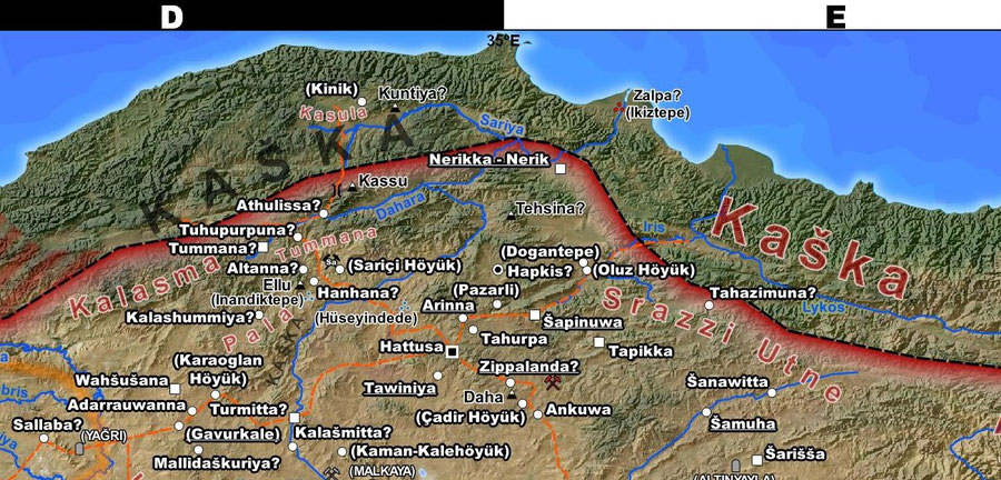
A part of the Hittite homeland and northern frontier zone. Especially in the Hittite parts of my new map a greater number of mountains will be labeled, which are mentioned regularly as point of reference in Hittite texts.
Since it is my goal to make most detailed map of the Hittite Empire possible today and not only a map of Bronze Age archaeological sites within the Hittite Empire, I chose to use periods names whenever they can be plausibly assigned to a place. Often these reconstructions are mere hypotheses, based on the similarity of names in Bronze Age sources to forms later attested in Classical times or place names found on cuneiform tablets that could very well also refer to neighboring towns.
Unfortunately, in most cases the space isn’t available to display both the ancient and modern name on the map in cases of doubt. However I plan to include an full index, as already available for the precursor map of Ancient Egypt, for all named places with modern, classical (if appropriate) and Bronze Age names.
A new feature I’ve added recently are former borders that reflect the political situation before 1250 BCE. These include not only Egypt’s northern border under Thutmosis III. or Hittite territories across the Euphrates already lost to the rising Middle Assyrian Empire, but also fallen kingdoms conquered by their neighbors as Arzawa in western Anatolia or the former Mittanni Empire.
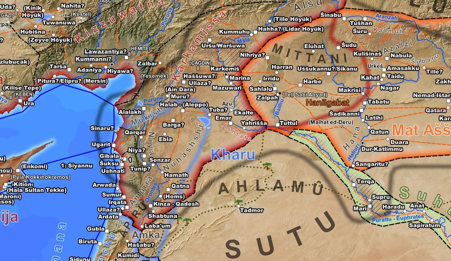
Diffuse borderlines highlight once Egyptian and Hittite controlled territories as well as the former Mitanni Empire before its destruction in the late 13th century BCE.
Beyond the Hittite borders I could also make a number of smaller additions to the new map. For one, the legend is now complete, at least until I decide to add more features, and the island of Malta on its own ancillary map was added.
After spending some more time researching the geography of the Hittite Empire, a task for which a few weeks are probably still required, I will again revisit Elam, for almost two millennia the great rival of the Mesopotamian Empires to the east until the rise of the Medes, and the other parts western Iran. I already did some work on it last spring after finishing Babylonia and before the Pandemic fully hit us, but was not able to finish this section. However in the meantime some new literature has became available to me and this time I will hopefully be sufficiently satisfied to make Elam and its neighbors the topic of my next preview.
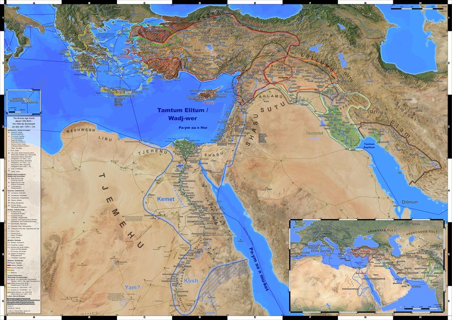
WIP: The current state of the upcoming DIN A0 sized wall map "The bronze Age World" with the latest additions.
Selected Bibliography
- M. Alparslan, M. Doğan-Alparslan, The Hittites and their Geography: Problems of Hittite Historical Geography, European Journal of Archaeology 18 (1) 2015, 90–110.
- G. Barjamovic, A Historical Geography of Anatolia in the Old Assyrian Colony Period, Museum Tusculanum Press (2011).
- T. Bryce, The Kingdom of the Hittites, Oxford University Press (2006).
- T. Bryce, The Routledge Handbook of the Peoples and Places of Ancient Western Asia: The Near East from the Early Bronze Age to the Fall of the Persian Empire, Routledge (2009).
- A. Godawa-Chrzanowska, Nachbarn des Oberen Landes - Politische Geographie der Grenzregionen des Reiches Hatti, Dissertation, Johannes Gutenberg-Universität Mainz (2020).
- Ali M. Dinçol, Y. Yarkar, B. Dinçol, A. Taffet, The Borders of the Appanage Kingdom of Tarhuntašša - A Geographical and Archaeological Assessment, Anatolica 26 (2000), 1-29.
- A. Engin, A Localisation Proposal for Oylum Höyük: Ulisum / Ullis / Illis, in Armizzi - Engin Özgen'e Armağan / Studies Honour of Engin Özgen, Ankara (2014), 129-149.
- M. Forlanini, Happurija, eine Hauptstadt von Arzawa?, in Belkıs Dinçol ve Ali Dinçol’a Armağan VITA Festschrift in Honor of Belkıs Dinçol and Ali Dinçol, Yayınları(2007), 285-298.
- M. Forlanini, On the Middle Kizilirmak II, Studia Asiana 5 (2009), 39-69.
- M. Forlanini, The Historical Geography of Western Anatolia in the Late Bronze Age, still an open question, Orientalia Vol. 81 Fasc.2 (2012), 133-140.
- M. Gander, Asia, Ionia, Maeonia und Luwiya? Bemerkungen zu den neuen Toponymen aus Kom el-Hettan (Theben-West) mit Exkursen zu Westkleinasien in der Spätbronzezeit, Klio 97 2 (2015), 443–502.
- C. Glatz and R. Matthews, Anthropology of a Frontier Zone: Hittite-Kaska Relations in Late Bronze Age North-Central Anatolia, BASOR 339 (2005), 47-65.
- C. Marek, P. Frei, Geschichte Kleinasiens in der Antike, 2. durchges. Aufl., C.H. Beck (2010).
- A. Matessi, The Making of Hittite Imperial Landscapes: Territoriality and Balance of Power in South-Central Anatolia during the Late Bronze Age, Journal of Ancient Near Eastern History 3(2) (2016), 117–162.
- R. Matthews and C. Glatz, The historical geography of north-central Anatolia in the Hittite period: texts and archaeology in concert, Anatolian Studies Vol. 59 (2009), 51-72.
- R. Oreshko, Geography of the Western Fringes - Gar(a)giša/Gargiya and the Lands of the Late Bronze Age Caria, in O. Henry, K. Konuk (eds.), KARIA ARKHAIA - La Carie, des origines à la période pré-hékatomnide, Institut Français d’Études Anatoliennes Georges Dumézil - CNRS USR 3131 (2013), 139-189.
- O. Pedersén, Ancient Near East on Google Earth: Problems, Preliminary results, and Prospects, in R. Matthews, J. Curtis, (eds.) Proceedings of the 7th International Congress on the Archaeology of the Ancient Near East, Harrassowitz Verlag (2012), 385-393. https://www.lingfil.uu.se/research/assyriology/earth/
- A. Ünal, A Hittite treaty tablet from Oylum Höyük in southeastern Turkey and the location of Ḫaššu(wa), Anatolian Studies Vol. 65 (2015), 19-34.
- C. H. Roosevelt, C. Luke, The Story of a Forgotten Kingdom? Survey Archaeology and the Historical Geography of Central Western Anatolia in the Second Millennium BC, European Journal of Archaeology 20 1 (2017), 120–147.
- D. Schürr, Zur Vorgeschichte Lykiens: Städtenamen in hethitischen Quellen, KLIO 92 (2010), 7-33.
- Anne-Maria Wittke, Eckart Olshausen, Richard Szydlak, Der neue Pauly. Historischer Atlas der antiken Welt, Metzler (2007).
- F. C. Woudhuizen, The Geography of the Hittite Empire and the Distribution of Luwian Hieroglyphic Seals, Klio 97.1 (2015), 7–31.
Write a comment
David (Sunday, 05 September 2021 14:33)
This is amazing! I've been searching for a comprehensive map like this for a long while. Keep up the great work!
ilknur akbaş (Sunday, 02 June 2024 11:23)
Is it possible to share the current map of the Late Bronze Age? We can see the details better.
Tabulae Geographicae (Sunday, 02 June 2024 14:26)
@ ilknur akbaş: You can view the map in the corresponding preview section of the Bronze Age part of the website: https://www.tabulae-geographicae.de/english/bronze-age/preview/